|
Planning & Regulatory Working Party Wednesday 29 April 2020 at 9.30am
|
|
|
|
|


|
Planning & Regulatory Working Party Wednesday 29 April 2020 at 9.30am
|
|
|
|
|
Planning and Regulatory Working Party
29 April 2020
Planning & Regulatory Working Party Agenda
Meeting to be held via Zoom video and teleconferencing
on Wednesday 29 April 2020, commencing at 9.30am
Please note: working parties and working groups carry NO formal decision-making delegations from council. The purpose of the working party/group is to carry out preparatory work and discussions prior to taking matters to the full council for formal consideration and decision-making. Working party/group meetings are open to the public to attend (unless there are specific grounds under LGOIMA for the public to be excluded).
MEMBERSHIP OF THE Planning & Regulatory Working Party
Cr Joce Yeoman (Chair)
|
Cr Amy Macdonald |
Cr Colin Kitchen |
Cr Justin Blaikie |
|
Cr Penny Smart (ex officio) |
Pita Tipene |
Juliane Chetham |
|
Rowan Tautari |
Mira Norris |
|
Item Page
1.0 apologies
2.0 declarations of conflicts of interest
3.1 Receipt of Meeting Notes 3
3.2 Planning and Policy Work Programme 8
3.3 Unconsented Grids 10
3.4 Plan change to implement the water quality planning requirements in the National Policy Statement for Freshwater Management 2017 12
3.5 Climate Change Related Provisions within Regional Planning Documents 53
3.6 New Regional Plan Implementation Plan
GM Regulatory Services will provide a verbal update
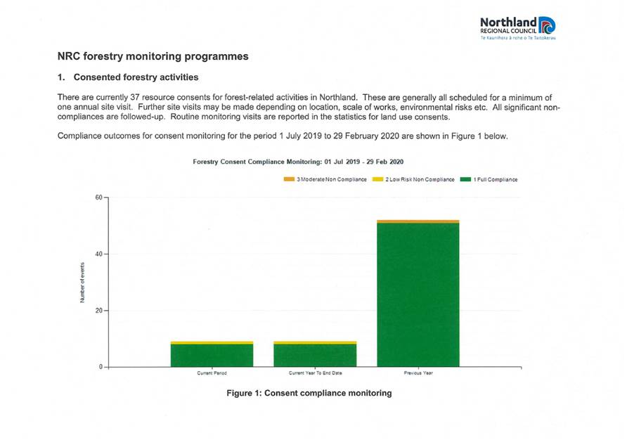
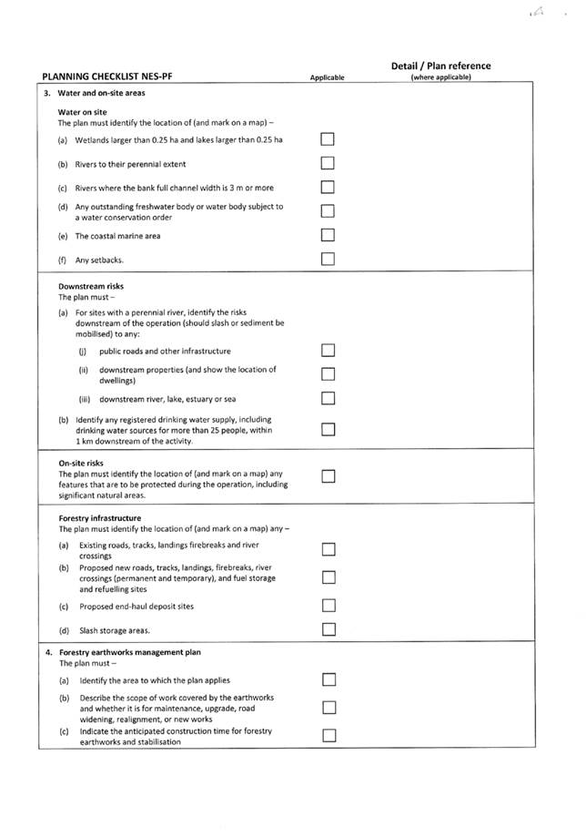
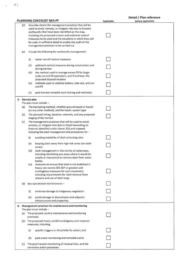
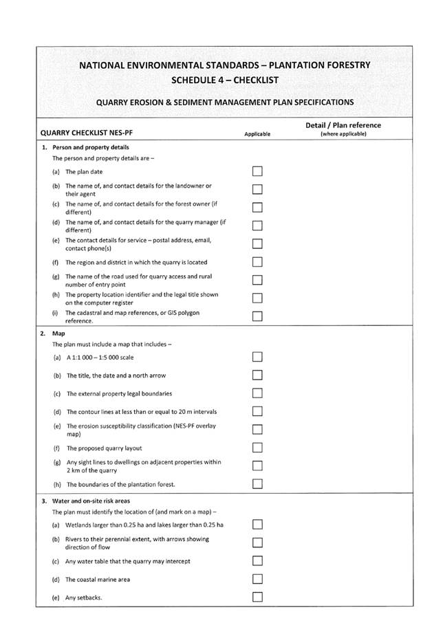
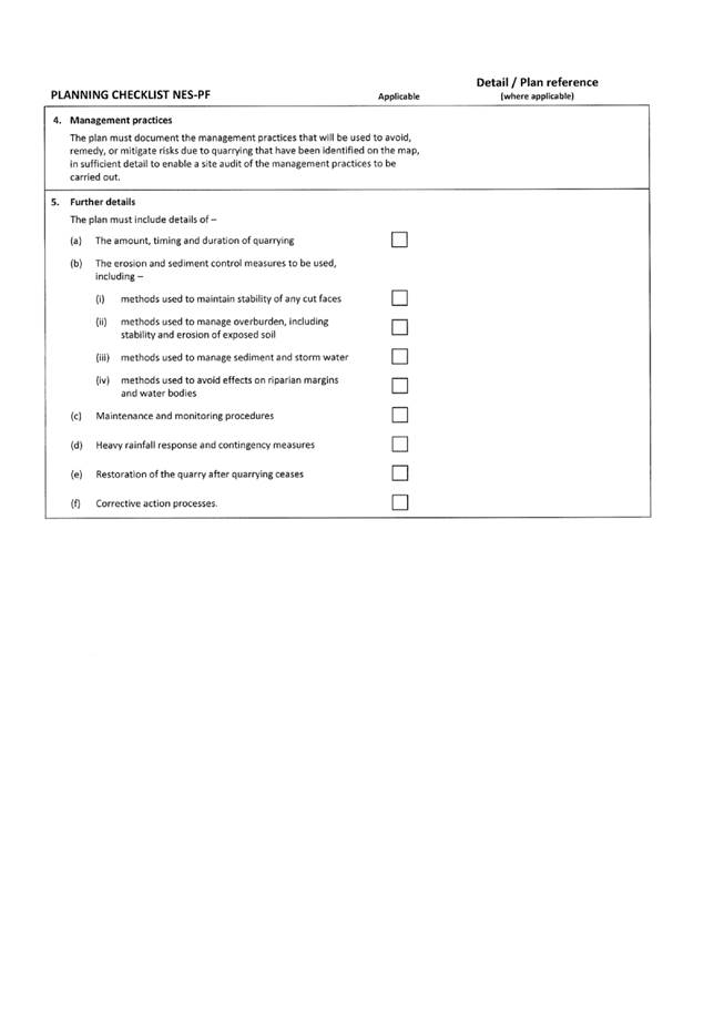
3.7 NRC Forestry Monitoring Programmes
Attachment 1 NRC Forestry Monitoring Programmes 57
3.8 Outstanding Marine Farm Bonds Protocol 73
3.9 Drought Update
GM Regulatory Services will provide a verbal update
3.10 Draft Compliance Monitoring & Enforcement Strategy 75
Planning and Regulatory Working Party item: 3.1
29 April 2020
|
TITLE: |
Receipt of Meeting Notes |
|
ID: |
A1296950 |
|
From: |
Rachael King, Planning & Policy Administrator |
Executive Summary | Whakarāpopototanga
The purpose of this report is to present the meeting notes from the last meeting held on 29 January 2020 for review by the meeting.
Attachments| Ngā tapirihanga
Attachment 1: Meeting Notes - 29
January 2020 ⇩ ![]()
Authorised by Group Manager
|
Name: |
Jonathan Gibbard |
|
Title: |
Group Manager - Strategy, Governance and Engagement |
|
Date: |
18 March 2020 |
29 April 2020
|
TITLE: |
Planning and Policy Work Programme |
|
ID: |
A1296518 |
|
From: |
Ben Lee, Strategic Policy and Planning Manager |
Executive Summary | Whakarāpopototanga
The Planning and Policy team’s work programme was presented to the January 2020 Planning and Regulatory Working Party meeting. The work programme is presented again for the benefit of the recently appointed TTMAC members of the Planning and Regulatory Working Party and to provide an update on progress on some items.
The following table sets out the work programme for the Planning and Policy team for the next three years. It only includes work relevant to the Planning and Regulatory Working Party’s terms of reference.
Note – the Coastal Occupation Charging and Mana Whakahono o Rohe activities have been updated since the January workshop.
|
Detail |
When |
|
|
Coastal occupation charging |
Develop regime options for further council direction on whether to proceed releasing a discussion document for public feedback |
June / July 2020 |
|
Marine protected areas |
Progressing Mimiwhangata proposal with Ngātiwai. Explore implications of recent case law on council’s ability to regulate fishing. |
TBC |
|
Wetland mapping |
Mapping project to clearly define wetlands and provide certainty about where wetland rules apply. Methodology and technology limitation mean final delivery date is unknown. |
TBC |
|
Freshwater quality management plan change |
A plan change to set freshwater quality objectives and limits and regulation to ensure the objectives are achieved and limits are met. Required to give effect to the Freshwater NPS |
Notify 2021 – separate item outlining detailed timeframes and deliverables.
|
|
Catchment-specific water quantity limits |
Possible plan change(s). Catchment-specific limits to replace regional ‘default’ limits for priority water bodies. Contingent on outcome of technical work in priority catchments. |
TBC (if at all) |
|
Proposed Regional Plan appeals |
Environment Court process. Through mediation to date, the parties have managed to reach consensus on the majority of appeal points (approx. 75% of the appealed provisions have now been agrees between the parties). Council staff are continuing to liaise with appeal parties in order to resolve further provisions. |
Hearings on unresolved matters start April 2020. |
|
District plan changes |
The planning team provide feedback and make submissions on changes to district plans. The main reasons are to ensure the RPS is being given effect and ensure council operations (e.g. flood management) are not unduly regulated. |
Ongoing |
|
District council consents (review / commentary) |
See explanation for district plan changes. |
Ongoing |
|
Treaty settlement process |
Supporting Treaty settlements as there are implications for council’s activities. Currently involved in the Kaipara Moana settlement process. |
Ongoing |
|
TOAT Beach Board (90 Mile Beach) |
Advice to board and leading / assisting with preparation of beach management plan. |
Advice to board – ongoing Beach management plan – complete early 2021 |
|
NRC input into national proposals (e.g. proposed NPS for biodiversity) |
Lead council input into national proposals (e.g. submissions and sitting on advisory groups). |
Ongoing |
|
Regional Plan guidance material |
Once the Plan (or parts of) are operative, the planning team will produce guidance material to assist with interpreting / implementing the Plan. |
Start mid 2020 |
|
Additional sites of significance to tangata whenua – plan change |
Possible plan change. Likely to piggy-back on other water related plan change. |
Notify 2021 |
|
Mana Whakahono o Rohe (MWR) |
Planning team assisting Maori relationships team with roll-out of joint hapū MWR. Will also be involved in developing any iwi based MWR |
Council approved joint hapū MWR February 2020. Next step is to roll out with active hapū. |
|
RPS – 5-year review |
RMA requires a review of the RPS. |
2021 |
· Nil – presented for information purposes only
Background | Tuhinga
Not relevant.
Authorised by Group Manager
|
Name: |
Jonathan Gibbard |
|
Title: |
Group Manager - Strategy, Governance and Engagement |
|
Date: |
19 March 2020 |
Planning and Regulatory Working Party item: 3.3
29 April 2020
|
TITLE: |
Unconsented Grids |
|
ID: |
A1296601 |
|
From: |
Michael Day, Natural Resources Policy Manager |
Executive Summary | Whakarāpopototanga
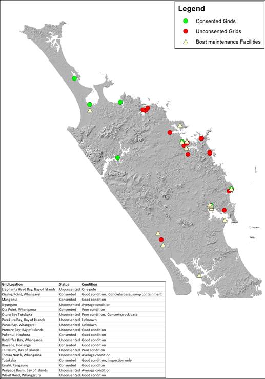
Coastal ‘Grids’ are structures located in the coastal marine area that are used in association with boat maintenance activities, such as inspection of vessel hulls, removal of micro-fouling marine growth and the cleaning of vessel hulls.
Throughout Northland, there are a mixture of consented and unconsented grids and the physical state of grids also varies throughout the region. As a general rule of thumb, the consented grids tend to be maintained in good order and repair, while the unconsented grids vary from being in reasonable order and repair to almost derelict.
It is understood that there are currently approximately thirteen unconsented grids in Northland. Over the years, there have been numerous incidents of misuse with unconsented grids (such as cleaning of hulls using high-pressure water abrasive blasters or using hand or power tools to remove marine growth (macro-fouling) from vessel hulls.
Council has historically had no authority to remove these structures, however, recent law changes have given council the ability to remove unauthorised structures if they are deemed to be ‘abandoned’ – council needs to undertake an exercise to determine this.
The Proposed Regional Plan for Northland does not have specific rules for grids, nor is there any policy guidance to test and determine the appropriates of these structures – they are treated as ‘coastal structures’. This means that most unconsented grids would be treated as ‘discretionary’ activities if a resource consent was sought to authorise their existence[1].
Whilst it is acknowledged that there needs to be facilities (accessible for all) for regularly cleaning vessel hulls to keep unwanted growth and invasive biosecurity risks at bay, this needs to be balanced against the need to respect and sustainably manage our marine environment.
It is noted that staff from council’s marine biosecurity team and coastal and water quality field operations team are undertaking background research into whether a policy (not necessarily an RMA ‘policy’) needs to be developed to potentially phase out unconsented grids. It is hoped that this can be brought back to this working party in the near future.
Relevant staff will attend this working party meeting to respond to questions.
1. That the Planning and Regulatory Working Party receive the paper and provide verbal feedback.
Background | Tuhinga
List and Location of Grids in Northland
Authorised by Group Manager
|
Name: |
Jonathan Gibbard |
|
Title: |
Group Manager - Strategy, Governance and Engagement |
|
Date: |
19 March 2020 |
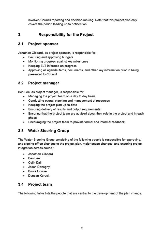
Planning and Regulatory Working Party item: 3.4
29 April 2020
|
TITLE: |
Plan change to implement the water quality planning requirements in the National Policy Statement for Freshwater Management 2017 |
|
ID: |
A1296877 |
|
From: |
Ben Tait, Policy Specialist - Water |
Executive Summary | Whakarāpopototanga
The purpose of this report is to:
1. Provide Council with an update on the project for developing a plan change to implement the water quality planning requirements of the National Policy Statement for Freshwater Management 2017 (NPS-FM); and
2. Seek Council’s feedback on an approach for engaging with communities, including tangata whenua, and key stakeholders in developing the plan change.
1. That the Working Party receives the Project Plan for implementing the water quality planning requirements of the NPS-FM.
2. That the Working Party provides feedback on the proposed approach for engaging with communities, including tangata whenua, and key stakeholders in developing the plan change.
3. That the Working Party seeks TTMAC feedback on how best to seek Māori participation in the plan change process prior to seeking Council formal approval.
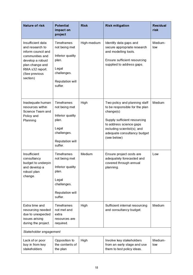
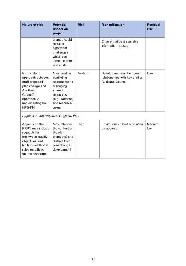
Background | Tuhinga
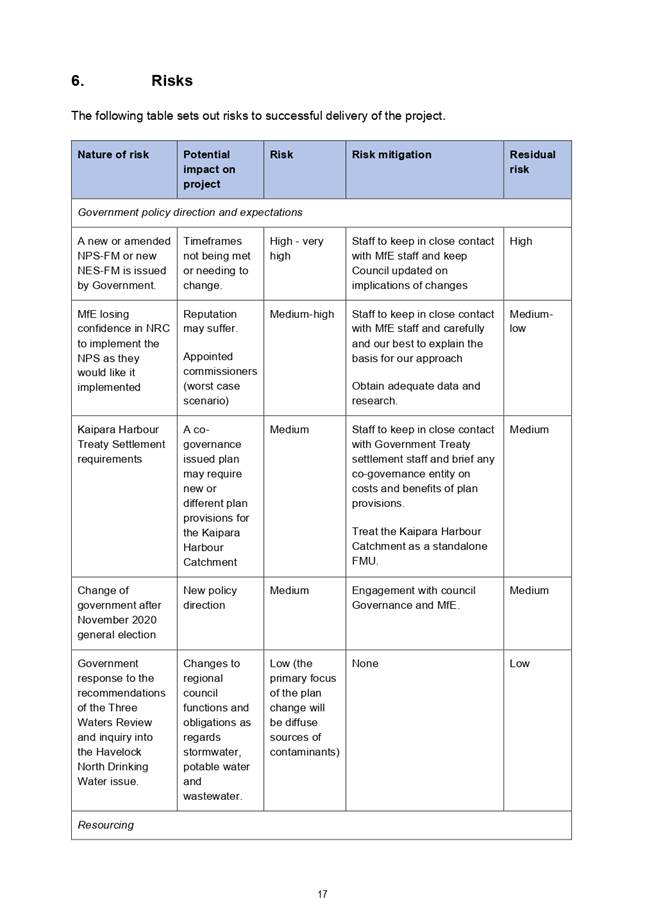
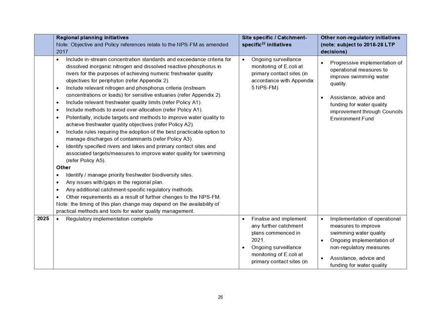
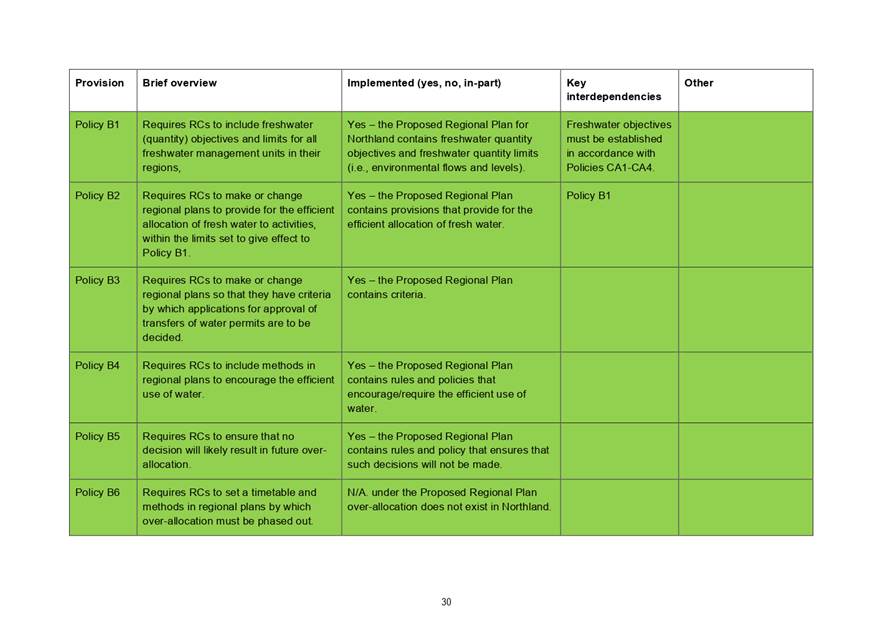
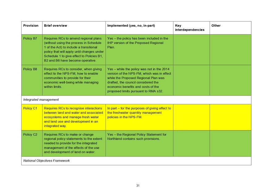
Northland Regional Council is in the early stages of preparing a plan change to implement the water quality planning requirements of the National Policy Statement for Freshwater Management. The plan change is scheduled to be notified late 2021.
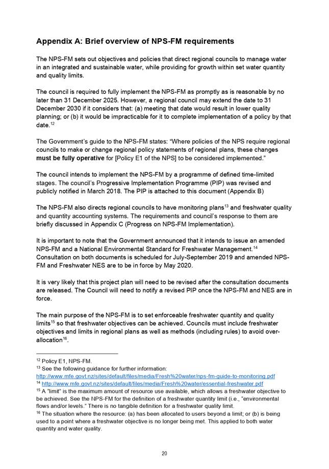
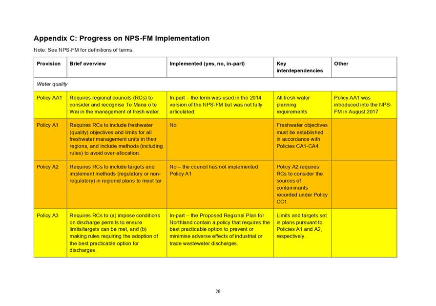
The NPS-FM, which was first issued in 2011, and subsequently amended in 2014 and 2017, directs regional councils to manage fresh water in an integrated and sustainable way, while providing for economic growth within set water quantity and quality limits[2].
Regional councils must include freshwater objectives and limits in regional plans as well as methods (including rules) to ensure that objectives are met, and limits not exceeded.
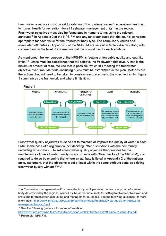
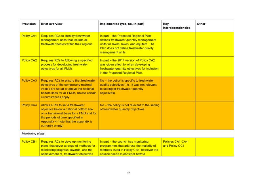
Freshwater objectives must be set to maintain or improve the quality of water in each freshwater management unit in order to safeguard “compulsory values” (ecosystem health and human health for recreation).
A “freshwater management unit” is a water body, multiple water bodies or any part of a water body determined by the regional council as the appropriate scale for setting freshwater objectives and limits and for freshwater accounting and management purposes.[3]
Council agreed to defining draft freshwater quality management units largely based on the catchments of major harbours.
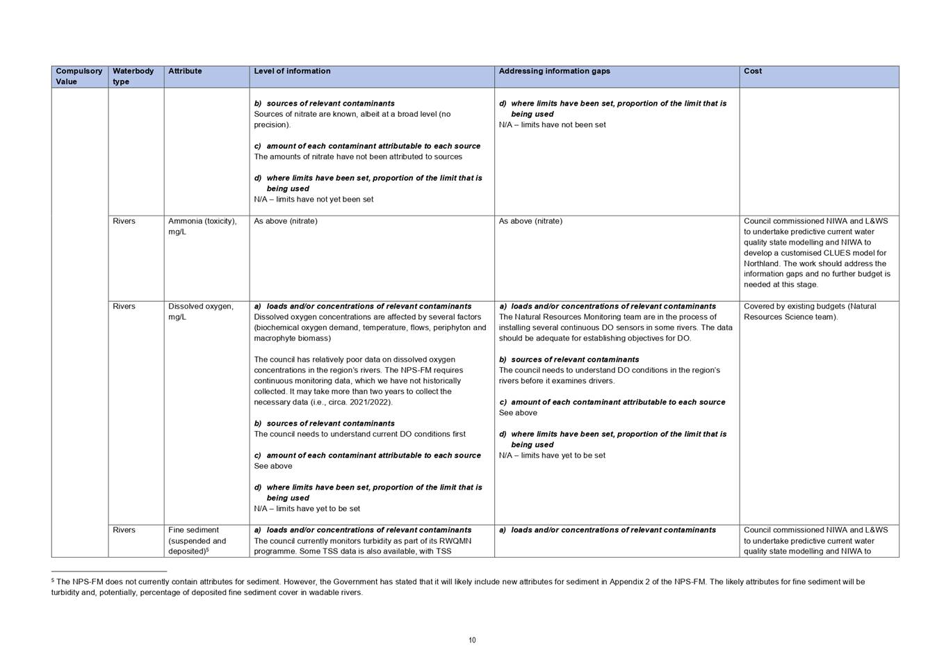
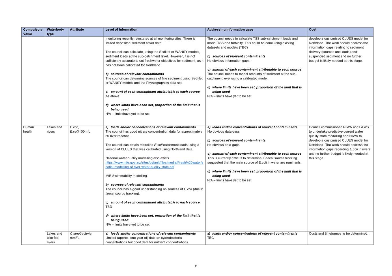
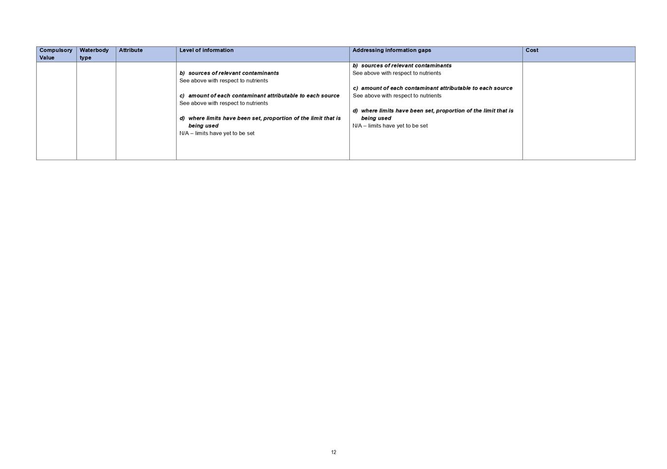
Freshwater objectives must also be formulated in numeric terms using the relevant attributes[4] in Appendix 2 of the NPS-FM and any other attributes that the council considers appropriate for each value for the freshwater body type.
Northland Regional Council committed to notifying a plan change in 2021 to implement the freshwater quality planning requirements of the NPS-FM. The commitment is set out in the council’s Progressive Implementation Programme[5]. The freshwater quantity planning requirements of the NPS-FM are already being implemented through the Proposed Regional Plan for Northland[6].
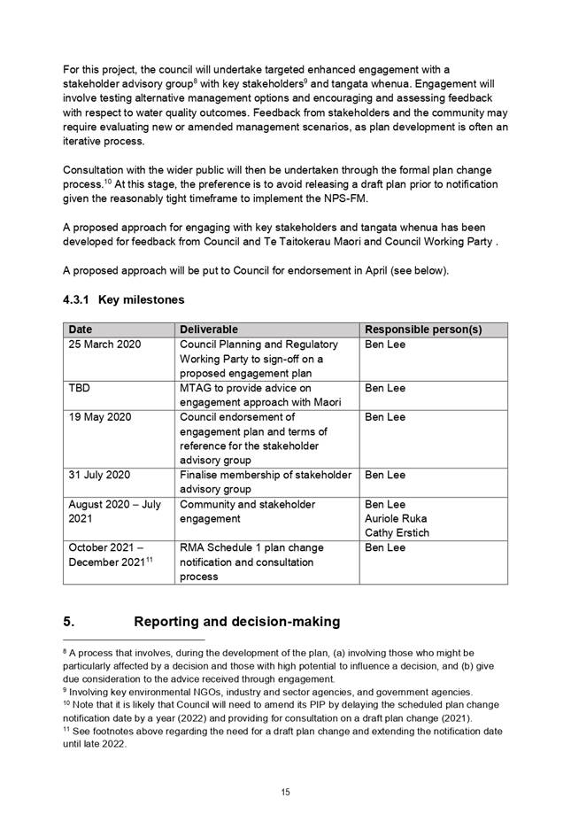
Council approved a timetable for developing the plan change to implement the freshwater quality planning requirements of the NPS-FM at its 18 June 2019 meeting. Key milestones are set out below:
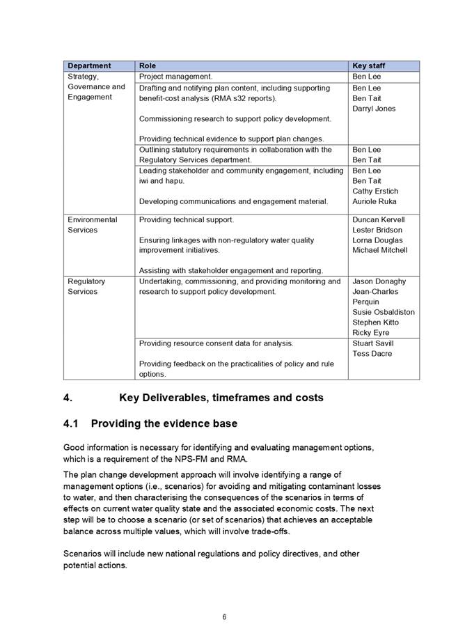
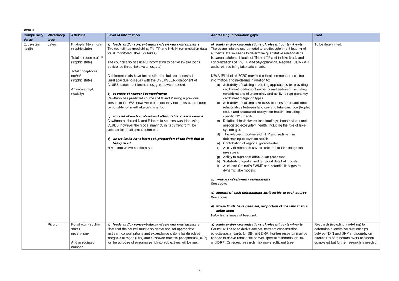
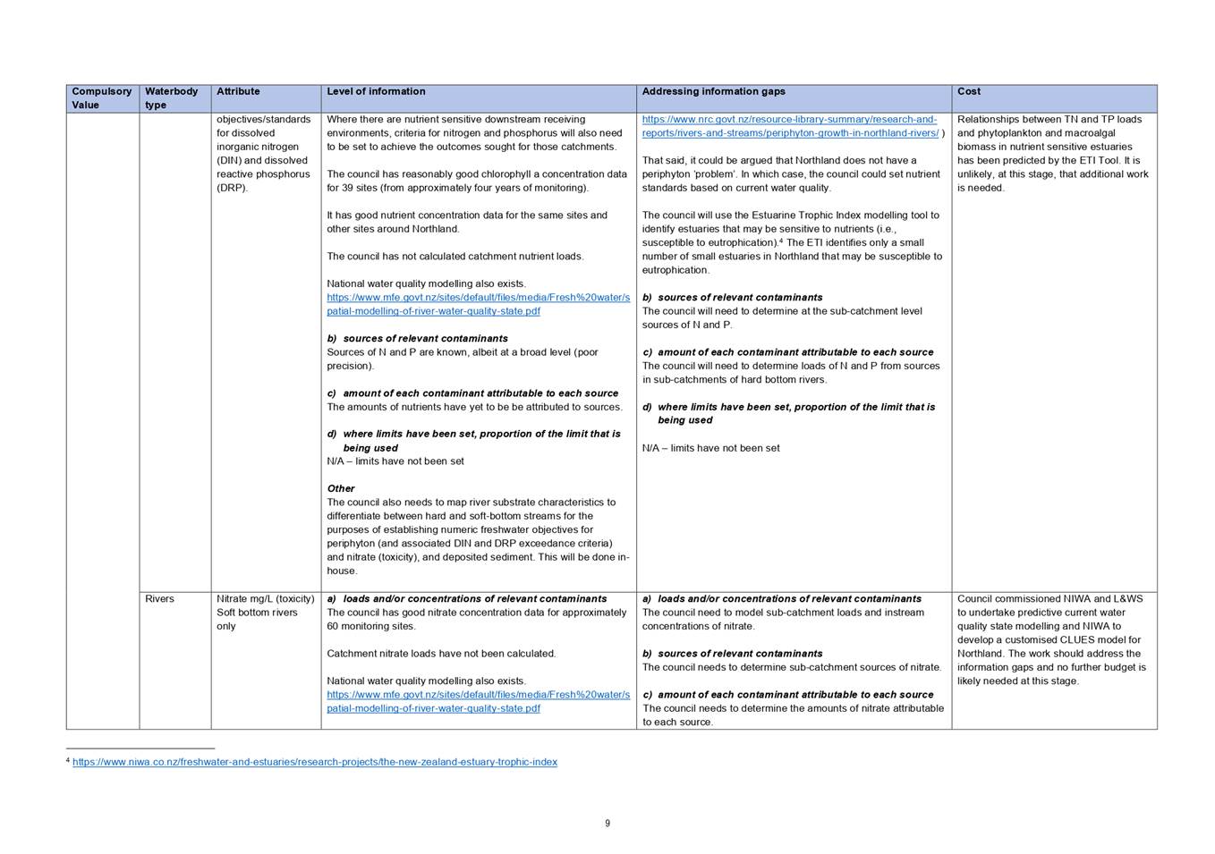
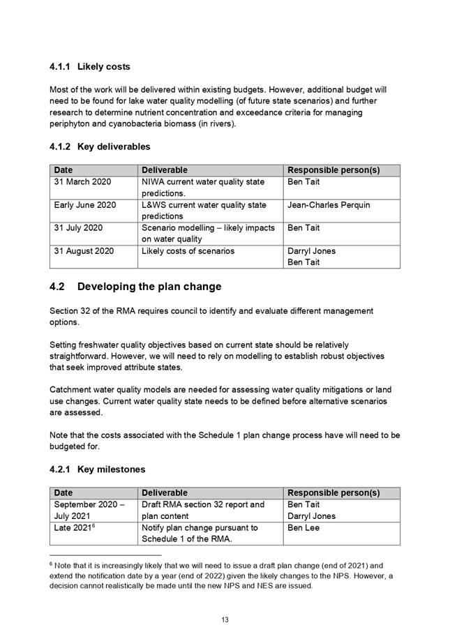
1. Provide the evidence base to underpin the plan change and any accompanying new non-regulatory initiatives (November 2019 – March 2021).
2. Draft the plan change and a RMA section 32 evaluation report (July 2020 – July 2021).
3. Notify the Proposed Water Quality Plan Change (by 31 December 2021).
4. Engage with iwi and hapū, key stakeholders and the wider community throughout the process.
The initial stages of the work programme to prepare the plan change are on track.
Further details on the work programme are set out in the attached project plan (Attachment 1). Meaningful engagement and discussions with the community, including iwi and hapū, and key stakeholders is essential to developing a robust plan change. Council staff have proposed a targeted approach that is summarised in the second attachment to this report (Attachment 2). Feedback on the approach is sought Council. It is recommended that TTMAC input be sought on the draft engagement proposal prior to presenting to Council for formal adoption.
Attachment 1: Project plan for
implementing the water quality planning requirements of the NPS-FM ⇩ ![]()
Attachment 2: Proposed approach for
engaging the community, including tangata whenua, and key stakeholders ⇩ ![]()
Authorised by Group Manager
|
Name: |
Jonathan Gibbard |
|
Title: |
Group Manager - Strategy, Governance and Engagement |
|
Date: |
22 April 2020 |
29 April 2020
Proposed approach for engaging with communities, including tangata whenua, and key stakeholders in developing a 2021 plan change
18 March 2020
Background
Council resolved to engage with communities, including iwi and hapū, and key stakeholders throughout the process of developing a plan change to implement the water quality planning requirements of the NPS-FM 2017.[7], [8] Notification of the plan change is scheduled to happen in 2021.
The plan change will contain:
· Identified water quality dependent values/uses for each FMU;
· Freshwater quality objectives and associated limits; and
· Methods to achieve objectives and ensure limits are adhered to.
The initial stages of council’s work programme to prepare the plan change is largely on track. Modelling of the likely effects of water quality mitigation measures on the state of water quality in Northland’s rivers and estuaries is scheduled to happen in July 2020, although the modelling is, to a large part, contingent on the content (and timing) of a new NPS-FM, National Environmental Standards for Freshwater Management, and Stock Exclusion Regulations.
The next key milestones (2020) are:
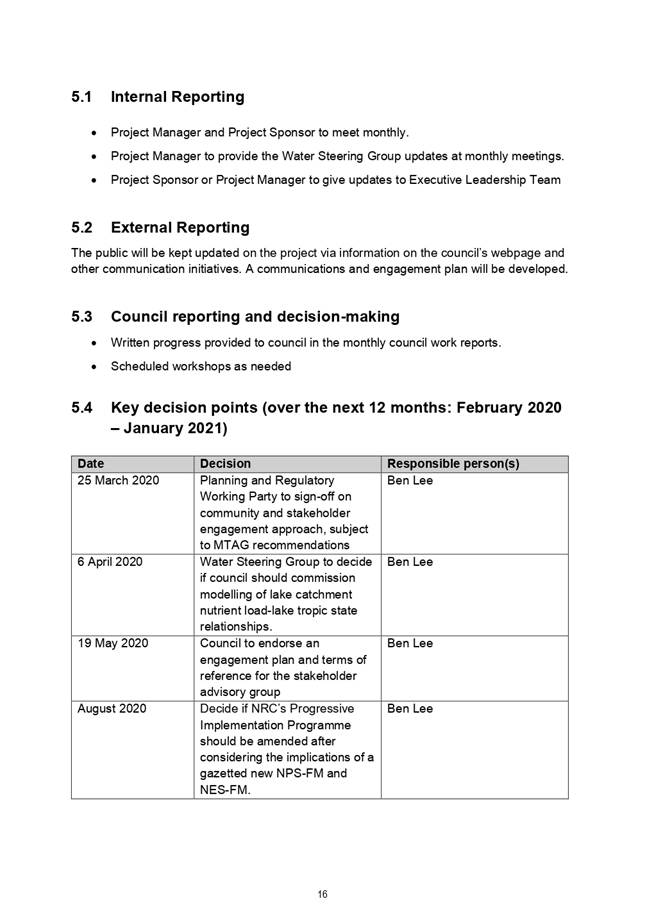
· Council agreeing to an engagement plan (19 May 2020);
· Iwi and hapū and key stakeholder engagement (August 2020 – July 2021); and
· Drafting the plan change and RMA s32 evaluation report (September 2020 – July 2021).
Proposed engagement approach
It is recommended that the proposed engagement should happen in two ways:
1. Targeted engagement with iwi and hapū and key stakeholders (August 2020 – July 2021); and
2. Broader engagement with communities and other stakeholders through consultation on the proposed plan change (late 2021).
Advice will be sought from Te Taitokerau Maori and Council Working Party on ow best to engage with iwi and hapū through the development of this plan change prior to confirming councils approach.
Engagement with key stakeholders should happen through a multi stakeholder advisory group, which may include councillor(s) and tangata whenua representatives.
The targeted engagement[9] with tangata whenua and the stakeholder advisory can be broadly grouped under the following themes, with the likely number of required meetings/workshops to be determined:
1. The plan change project (purpose, timeframes, how Council will consider input on the drafting of the plan, etc);
2. Overview of current water quality state and identified water quality related uses and values;
3. Overview of the existing and potential new water quality mitigation measures, and their likely impact on freshwater and estuarine water quality; and
4. Identifying and assessing the consequences of any additional scenarios.
Targeted engagement
In July 2019, Te Taitokerau Māori and Council Working Party agreed that council staff should work with Māori Technical Advisory Group (MTAG) “to develop recommendations on how to identify tangata whenua values and interests in wai Māori, how to reflect tangata whenua values in decision-making regarding the plan change, and to seek the MTAG’s feedback on the draft freshwater quality management units.”
While implicit in the resolution of the MTAG, it is proposed that we ask for its advice on how to engage iwi and hapū in developing the plan change. One option is to just use MTAG as a sounding board and for advice. The other options are to engage with TTMAC or more broadly.
The purpose of a ‘stakeholder advisory group’ will be to provide advice on planning options (i.e., act as a sounding board) for managing fresh and receiving coastal water quality in Northland. Terms of reference will be drafted at put to the Water Steering Group for endorsement prior to requesting membership invitations.
Following Council endorsement of forming a stakeholder advisory group, council should invite key environmental NGOs, industry and sector groups, and government agencies to join the group, i.e., organisations that represent the main interests in a water quality plan change. Council should also consider appointing one or more elected members to the group as observers.
Broader engagement
It is proposed that broader engagement with the community and other stakeholders happens through consultation on the proposed plan change. It is expected, however, that the views of the key stakeholders and iwi and hapū will largely represent the range of views in the community.
29 April 2020
|
TITLE: |
Climate Change Related Provisions within Regional Planning Documents |
|
ID: |
A1296893 |
|
From: |
Michael Day, Natural Resources Policy Manager |
Executive Summary | Whakarāpopototanga
Under the Resource Management Act 1991, local government is required to consider the effects of a changing climate on communities. Additionally, a climate change perspective is now integrated into many of the activities that the regional council undertakes (such as the production of coastal hazard mapping and the development of flood management schemes).
This document outlines the provisions in the Regional Policy Statement for Northland (RPS) and the Proposed Regional Plan for Northland (PRP) that are directly focused on/explicitly mention ‘Climate Change’.
It is acknowledged that there are multiple provisions (policies, methods and rules) in both the RPS and PRP that ‘indirectly’ relate to climate change (such as the entire natural hazards section of the RPS, the taking and use of water section of the PRP and all the natural hazard policies in the PRP). Most of these provisions have not been included in this document as the intention is to keep this paper focused on the provisions directly mentioning climate change.
1. That the Planning and Regulatory Working Party receive the paper and provide verbal feedback.
Background| Tuhinga
RPS for Northland Climate Change provisions
Issue 2.7 – Natural Hazards
Natural hazards, particularly flooding and coastal erosion and inundation, have the potential to create significant risk to human life, property, community and economic wellbeing in Northland. This risk is projected to increase as a result of a changing climate.
Objective 3.13 – Natural hazard risk
The risks and impacts of natural hazard events (including the influence of climate change) on people, communities, property, natural systems, infrastructure and our regional economy are minimised by:
(a) Increasing our understanding of natural hazards, including the potential influence of climate change on natural hazard events;
(b) Becoming better prepared for the consequences of natural hazard events;
(c) Avoiding inappropriate new development in 10 and 100 year flood hazard areas and coastal hazard areas;
(d) Not compromising the effectiveness of existing defences (natural and man-made);
(e) Enabling appropriate hazard mitigation measures to be created to protect existing vulnerable development; and
(f) Promoting long-term strategies that reduce the risk of natural hazards impacting on people and communities.
(g) Recognising that in justified circumstances, critical infrastructure may have to be located in natural hazard-prone areas.
Policy 6.1.2 – Precautionary approach
Adopt a precautionary approach towards the effects of climate change and introducing genetically modified organisms to the environment where they are scientifically uncertain, unknown, or little understood, but potentially significantly adverse.
Policy 7.1.4 – Existing development in known hazard prone areas
In 10-year and 100-year flood hazard areas and coastal hazard areas, mitigation measures to reduce natural hazard risk to existing development will be encouraged. These may include one or more of the following:
(a) Designing for relocatable or recoverable structures (when changing existing buildings);
(b) Providing for low or no risk activities within hazard-prone areas;
(c) Providing for setbacks (from rivers / streams or the coastal marine area);
(d) Managed retreat by relocation, removal, or abandonment of structures;
(e) Replacing or modifying existing development without resorting to hard protection structures (see Policy 7.2.2); or
(f) Protecting, restoring or enhancing natural defences against natural hazards (see Policy 7.2.1).
Policy 7.1.6 – Climate change and development
When managing subdivision, use and development in Northland, climate change effects will be included in all estimates of natural hazard risk, taking into account the scale and type of the proposed development and using the latest national guidance and best available information on the likely effects of climate change on the region or district.
Method 7.1.7 (7)
The regional and district councils, when setting out objectives, policies, and methods in regional and district plans, and when assessing resource consent applications, will take into account the latest national guidance and the best available information on the effects of climate change on natural hazards for sea-level rise, drought and storm rainfall intensity.
Method 7.1.8 (1)
The regional council, when undertaking its functions under section 30 of the Resource Management Act 1991, will co-ordinate the gathering and collating of research at a regional scale on flooding and coastal hazards (including tsunami) and the effects of climate change on these hazards.
Method 7.1.9 (2)
The regional and district councils shall raise public awareness of natural hazards, including providing and publicising information on which natural hazards may occur in various locations (including the potential influence of climate change on these hazards) and what people can do to be prepared for hazard events.
PRP for Northland climate change provisions
Objective F.1.9 – Natural hazard risk
The risks and impacts of natural hazard events (including the influence of climate change) on people, communities, property, natural systems, infrastructure and the regional economy are minimised by:
1) increasing the understanding of natural hazards, including the potential influence of climate change on natural hazard events, and
2) becoming better prepared for the consequences of natural hazard events, and
3) avoiding inappropriate new development in 100-year flood hazard areas and coastal hazard areas, and
4) not compromising the effectiveness of existing natural and man-made defences against natural hazards, and
5) enabling appropriate hazard mitigation measures to be implemented to protect existing vulnerable development, and
6) promoting long-term strategies that reduce the risk of natural hazards impacting on people and communities, and
7) recognising that in justified circumstances, critical infrastructure may have to be located in natural hazard-prone areas.
Policy D.2.3 – Climate change and development
Particular regard must be had to the potential effects of climate change on a proposed development requiring consent under this Plan, taking into account the scale, type and design-life of the development proposed and with reference to the latest national guidance and best available climate change projections.
Policy D.6.1 – Appropriateness of hard protection structures
New hard protection structures may be considered appropriate when:
1) alternative responses to the hazard (including soft protection measures, restoration or enhancement of natural defences against coastal hazards and abandonment of assets) are demonstrated to be impractical or have greater adverse effects on the environment, or
2) they are the only practical means to protect:
a) existing or planned regionally significant infrastructure, or
b) existing core local infrastructure, or
c) concentrations of existing vulnerable development, and
d) they provide a better outcome for the local community, district or region, compared to no hard protection structure, and the works form part of a long-term hazard management strategy, which represents the best practicable option for the future.
Policy D.6.2 – Design and location of hard protection structures
New hard protection structures must:
1) be located as far landward as possible in order to retain existing natural defences against coastal hazards as much as possible, and
2) be designed and constructed by a suitably qualified and experienced professional, and
3) incorporate the use of soft protection measures where practical, and
4) be designed to take into account the nature of the coastal hazard risk and how it might change over at least a 100-year time-frame, including the projected effects of a sea level rise of one metre by 2115 (100 years).
Policy D.6.3 – Re-building of materially damaged or destroyed buildings in high risk hazard areas
Resource consent may only be granted for the re-building of materially damaged or destroyed buildings in high-risk flood hazard areas and high-risk coastal hazard areas if the natural hazard risk to the building is demonstrated to be reduced (compared with the risk to the building previously) and hazard risk to other property is not increased.
Rule C.8.6.1 - Re-building of materially damaged or destroyed buildings – restricted discretionary activity
The re-building of a habitable building in a high-risk coastal hazard area or high-risk flood hazard area that has been materially damaged or destroyed by flooding, erosion or land instability caused by a natural hazard event is a restricted discretionary activity, provided the application for the resource consent includes a natural hazard assessment from a suitably qualified professional.
Matters of discretion:
1) The location and design of the building to withstand natural hazard risk, taking into account the nature of the hazard risk and how it might change over a 100-year timeframe, including the expected effects of climate change.
2) Measures to avoid exacerbating the existing natural hazard risk as a result of the proposed re-building.
3) Measures to avoid increasing natural hazard risks on other property.
For the avoidance of doubt this rule covers the following RMA activities:
· Re-building of materially damaged or destroyed buildings (s9(2)).
Rule C.8.6.2 - Re-building of materially damaged or destroyed buildings – non complying activity
The re-building of a habitable building in a high-risk coastal hazard area or high-risk flood hazard area that has been materially damaged or destroyed by flooding, erosion or land instability caused by a natural hazard event, that is not a restricted discretionary activity under Rule C.8.6.1 _C.8.6.1_Re-building_of_C.8.6.1_Re-building_of_C.8.6.1_Re-building_ofis a non-complying activity.
For the avoidance of doubt this rule covers the following RMA activities:
· Re-building of materially damaged or destroyed buildings (s9(2)).
Authorised by Group Manager
|
Name: |
Jonathan Gibbard |
|
Title: |
Group Manager - Strategy, Governance and Engagement |
|
Date: |
19 March 2020 |
29 April 2020
|
TITLE: |
Outstanding Marine Farm Bonds Protocol |
|
ID: |
A1308154 |
|
From: |
Colin Dall, Group Manager - Regulatory Services |
Executive Summary | Whakarāpopototanga
Almost all marine farms in Northland are oyster farms and since 2010 almost all of those (built) farms have required a bond or bond alternative under their coastal permits to recover the clean-up costs from permit holders in respect of any farms that fell into disrepair or disuse.
After little progress had been made by individual oyster farmers to set up bonds for their permits, the New Zealand Oyster Industry Association set up an industry-based fidelity-type fund as an alternative to individual oyster farm bonds lodging cash or surety bonds on their permits.
Approximately 50% of Northland oyster farms are now covered by the fund, but the bonds for many of the remaining oyster farms are still outstanding.
Bond amounts are based on the developed (built) area or “horizontal lineal metres of racks” within farms, which were last mapped accurately in 2012.
The following protocol is proposed to get marine farm permit holders who haven’t met the bond requirements of their permits to put in place the bond or alternative surety required by their permits:
· Re-mapping of the current built area of, and horizontal lineal metres of racks within, farms using aerial imagery was collected by the Lidar surveys undertaken by the council. [This will also be used to validate the adequacy of existing bonds for marine farms.]
· Send out letters to all permit holders without a bond by end of May 2020 stating the required bond for their farm(s) and give them a deadline of 30 October 2020 to put in place a bond arrangement. Bond options will be provided within the letter, including cash, bank surety and the fidelity fund.
· Take enforcement action, such as abatement and infringement notices, against permit holders that do not meet the deadline to enter into a bond arrangement.
1. The Group Manager finalises the protocol after receiving feedback from the Working Party.
Background | Tuhinga
Following a review of conditions on coastal permits for marine farms commenced in 2005, the council resolved to impose new conditions on those permits which would allow it to recover clean-up costs from permit holders in respect of any farms that fell into disrepair or disuse. Almost all marine farms in Northland are oyster farms.
A hearing was required to determine the proposed new permit conditions, which was conducted by an independent hearing committee. The committee released its Final Decision on the new consent conditions on 21 April 2010, which imposed the following conditions relating to financial security for clean-up of oyster farms:
Bond
15 Within six months of the date of commencement of this reviewed condition, the permit holder shall enter into and thereafter maintain a bond with the regional council. Subject to conditions 19 and 22 the bond shall be in the amount of:
i. $6.95 per horizontal lineal metre of racks within the area approved by this permit; or alternatively,
ii. $9,000 per developed hectare within the area approved by this permit
Alternative (a) or (b) shall be the choice of the permit holder
The form of the bond shall be a bank or other surety acceptable to the regional council.
If a bond is provided by a bank or other surety, then it will be prepared by the regional council’s solicitor, and shall be signed and sealed by both parties. All costs associated with the preparation and registration of the bond shall be met by the permit holder.
Alternative to bond
19 The requirement for a bond pursuant to conditions 15-18 (inclusive) hereof may be waived by the regional council if the permit holder is able to satisfy the regional council, either within six months of the date of commencement of this reviewed condition or at any time during the term of a bond or other surety already established under condition 15 hereof, that the permit holder has secured the risk of marine farm removal costs pursuant to an alternative arrangement on terms acceptable to the regional council.
By mid-2012, oyster farmers had made little progress towards meeting the bond/financial security conditions of their permits. However, the New Zealand Oyster Industry Association (NZOIA) proposed an industry-based fidelity-type fund as an alternative to individual oyster farm bonds lodging cash or surety bonds on their permits.
The NZOIA, working with council staff, took almost a year to develop its proposed alternative to a form acceptable to the council. The alternative fund then took further time to set up and implement but since then has been running for a number of years. Approximately 50% of Northland oyster farms are now covered by the fund. The bonds for many of the remaining oyster farms are still outstanding.
Authorised by Group Manager
|
Name: |
Colin Dall |
|
Title: |
Group Manager - Regulatory Services |
|
Date: |
22 April 2020 |
Planning and Regulatory Working Party item: 3.10
29 April 2020
|
TITLE: |
Draft Compliance Monitoring & Enforcement Strategy |
|
ID: |
A1307913 |
|
From: |
Colin Dall, Group Manager - Regulatory Services |
Executive Summary | Whakarāpopototanga
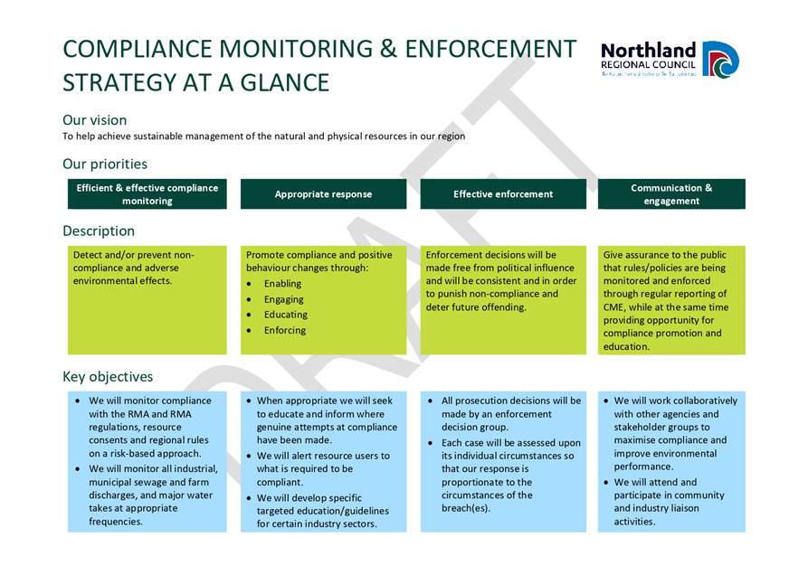
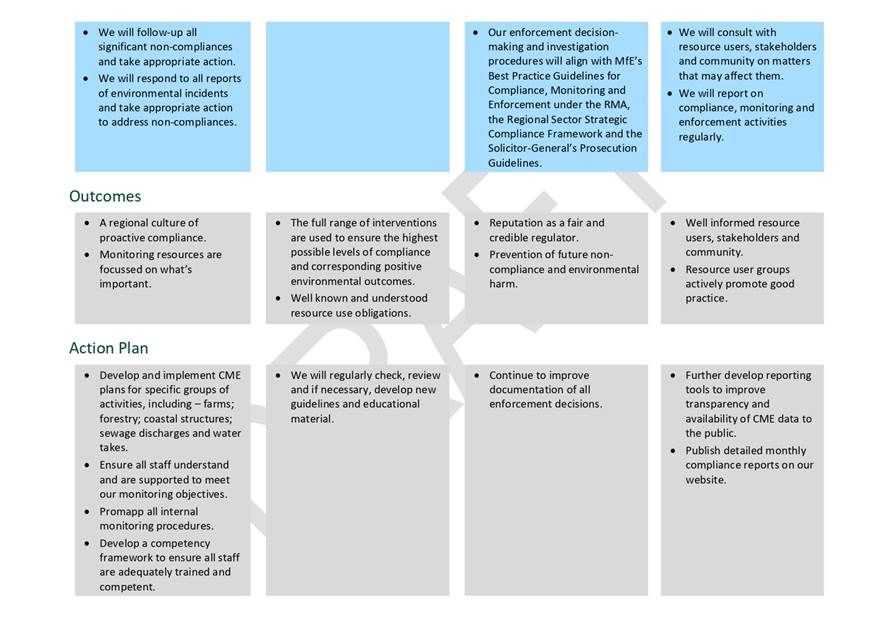
Attached for the Planning & Regulatory Working Party’s consideration and feedback is a draft Compliance Monitoring & Engagement Strategy.
The purpose of the CME Strategy is to provide overarching direction on how the Northland Regional Council plans to meet its compliance monitoring and enforcement (CME) responsibilities under the Resource Management Act 1991 (the RMA) and the outcomes it is seeking to achieve.
Recommended Actions
1. That Working Party members provide feedback on the draft
Background | Tuhinga
The council has statutory responsibilities under the RMA to:
· Monitor and enforce the resource consents it grants and the rules in its regional plans.
· Respond to reports (complaints) of breaches of the RMA and take appropriate action to address breaches where established.
· Enforce the observance of national environmental standards and other regulations promulgated under the RMA.
The action the council takes to meet these responsibilities is set out in a range of documents including manuals, activity management plans, procedures and protocols. However, currently there is no overarching document that “tells the story” in a concise and simple manner how the council meets these responsibilities and the outcomes it is seeking to achieve.
Attachment 1: DRAFT Compliance
Monitoring Enforcement Strategy ⇩ ![]()
Authorised by Group Manager
|
Name: |
Colin Dall |
|
Title: |
Group Manager - Regulatory Services |
|
Date: |
22 April 2020 |
[1] It would be treated as a non-complying activity in a mapped ‘significant’ area
[2] A “limit” is the maximum amount of resource use available, which allows a freshwater objective to be achieved.
[3] See the following guidance for more information: http://www.mfe.govt.nz/sites/default/files/media/Fresh%20water/guide-to-freshwater-management-units_0.pdf
[4] See the following guidance for more information: http://www.mfe.govt.nz/sites/default/files/media/Fresh%20water/a-draft-guide-to-attributes.pdf
[5]https://www.nrc.govt.nz/media/9590/northlandregionalcouncilsprogrammeforimplementingthenationalpolicystatementforfreshwatermanagementmarch2018.pdf
[6] Council is likely to progress a plan change in the future to set catchment specific water quantity limits on a prioritised catchment basis. This work, and the seeking of advice regarding the involvement of tangata whenua in the plan change, will be brought to a future TTMAC meeting.
[7] Namely, policies A1, A2, A3(a) and A5 and other relevant associated policies, e.g., AA1, CA1 and CA2.
[8] The NPS-FM 2017 requires councils to engage with communities and tangata whenua when establishing freshwater objectives. It is important to note that the proposed new National Policy Statement for Freshwater Management (MfE, 2019) will, if enacted, place significant new engagement requirements on regional councils.
[9] A process that involves, during the development of the plan, (a) involving those who might be particularly affected by a decision and those with high potential to influence a decision, and (b) give due consideration to the advice received through engagement.