|
Biosecurity and Biodiversity Working Party Wednesday 16 June 2021 at 1.00pm
|
|
|
|
|


|
Biosecurity and Biodiversity Working Party Wednesday 16 June 2021 at 1.00pm
|
|
|
|
|
Biosecurity and Biodiversity Working Party
16 June 2021
Biosecurity and Biodiversity Working Party Agenda
Meeting to be held in the Council Chamber
36 Water Street, Whangārei
on Wednesday 16 June 2021, commencing at 1.00pm
Please note: working parties and working groups carry NO formal decision-making delegations from council. The purpose of the working party/group is to carry out preparatory work and discussions prior to taking matters to the full council for formal consideration and decision-making. Working party/group meetings are open to the public to attend (unless there are specific grounds under LGOIMA for the public to be excluded).
MEMBERSHIP OF THE Biosecurity and Biodiversity Working Party
Chairperson, NRC Councillor Jack Craw
|
Councillor Justin Blaikie |
Councillor Marty Robinson |
Councillor Rick Stolwerk |
|
Ex Officio Penny Smart |
TTMAC representative Georgina Connelly |
TTMAC representative Juliane Chetham |
|
TTMAC representative Michelle Elboz |
TTMAC representative Nora Rameka |
|
KARAKIA
RĪMITI (ITEM) Page
1.0 Ngā Mahi Whakapai/Housekeeping
2.0 Ngā Whakapahā/apologies
3.0 Ngā Whakapuakanga/declarations of conflicts of interest
4.1 Record of Actions – Biosecurity and Biodiversity Working Party - 10 March 2021 3
4.2 Receipt of Action Sheet - Biosecurity and Biodiversity Working Party 6
4.3 Draft Biosecurity Operational Plan 8
4.4 Spartina eradication 35
4.5 Pest Fish 39
4.6 Dune Monitoring Update 43
4.7 General Updates 46
Biosecurity and Biodiversity Working Party item: 4.1
16 June 2021
|
TITLE: |
Record of Actions – Biosecurity and Biodiversity Working Party - 10 March 2021 |
|
ID: |
A1448383 |
|
From: |
Leah Porter, PA/Administrator Environmental Services |
|
Authorised by Group Manager: |
Jonathan Gibbard, Group Manager - Environmental Services, on 08 June 2021 |
Executive summary
The purpose of this report is to present the Record of Actions of the last meeting (attached) held on 10 March 2021 for review by the meeting.
Attachments/Ngā tapirihanga
Attachment 1: Biosecurity and
Biodiversity Working Party - 10 March 2021 ⇩ ![]()
16 June 2021
|
TITLE: |
Receipt of Action Sheet - Biosecurity and Biodiversity Working Party |
|
ID: |
A1449975 |
|
From: |
Leah Porter, Trainer |
|
Authorised by Group Manager: |
Jonathan Gibbard, Group Manager - Environmental Services, on 08 June 2021 |
Whakarāpopototanga / Executive summary
The purpose of this report is to enable the meeting to receive the current action sheet. While the action sheet currently only has actions from the last Working Party meeting, this will slowly grow as actions are identified by the Working Party and progress tracked through this Action Sheet.
That the action sheet be received.
Attachments/Ngā tapirihanga
Attachment 1: Biosecurity and
Biodiversity Working Party Action Tracker ⇩ ![]()
Biosecurity and Biodiversity Working Party item: 4.3
16 June 2021
|
TITLE: |
Draft Biosecurity Operational Plan |
|
ID: |
A1447580 |
|
From: |
Don McKenzie, Biosecurity Manager and Louise Orford, Biosecurity Officer - Systems Support |
|
Authorised by Group Manager: |
Jonathan Gibbard, Group Manager - Environmental Services, on 08 June 2021 |
Executive summary/Whakarāpopototanga
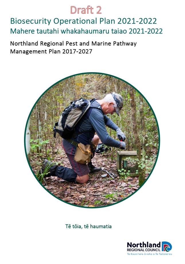
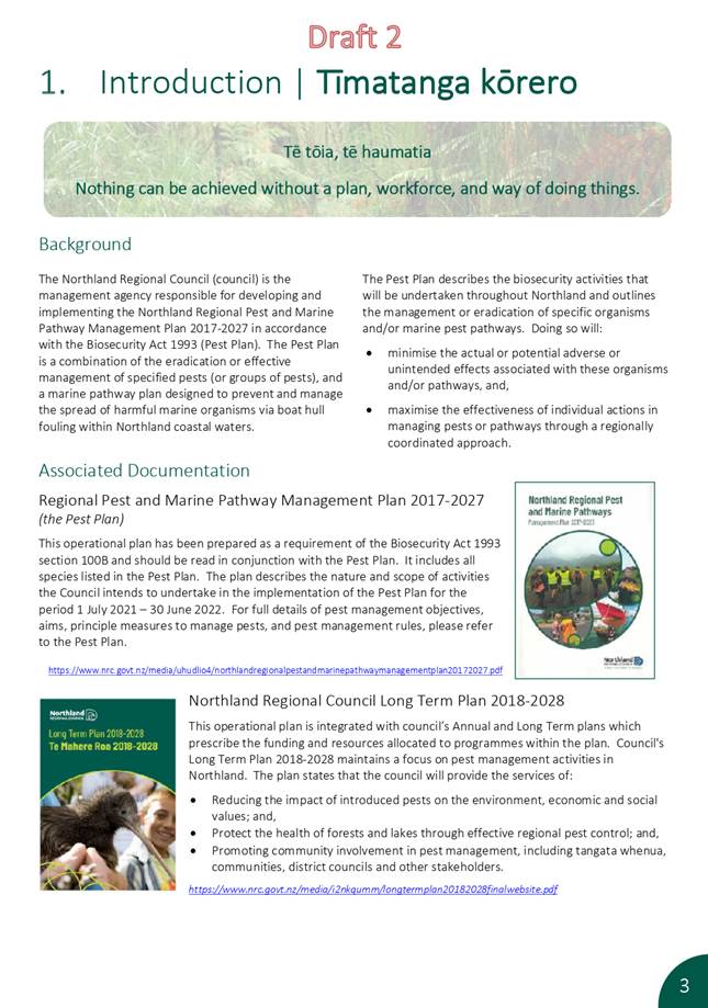
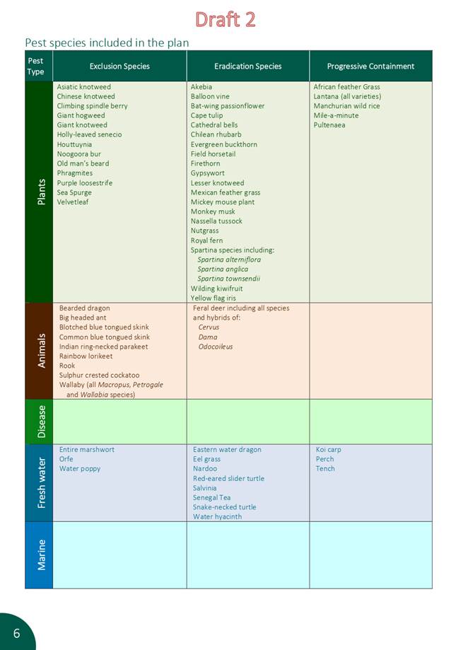
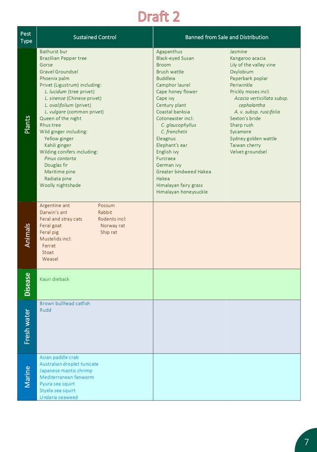
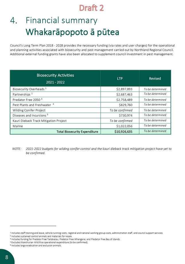
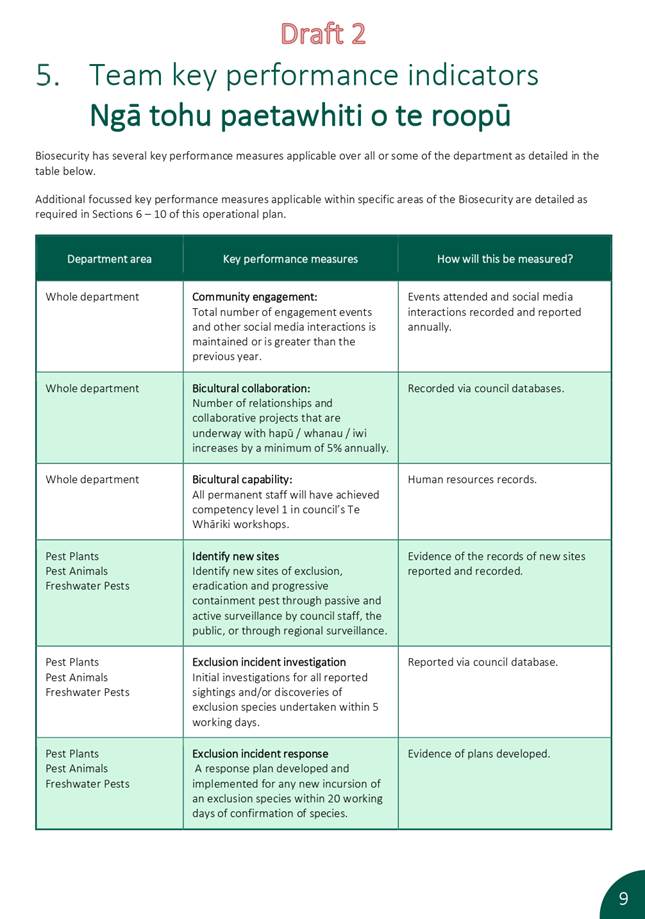
The attached draft Operational Plan has been prepared as a requirement of the Biosecurity Act 1993 section 100B and should be read in conjunction with the Northland Regional Pest and Marine Pathway Management Plan 2017–2027 (hereafter referred to as the Pest Plan). It includes all species listed in the Pest Plan and describes how biosecurity programmes will be implemented during the 2021/2022 financial year.
Recommendation(s)
1. That the report ‘Draft Biosecurity Operational Plan’ by Don McKenzie, Biosecurity Manager and Louise Orford, Biosecurity Officer - Systems Support and dated 26 May 2021, be received.
2. That the Biosecurity and Biodiversity Working Party recommend the Draft Northland Regional Pest and Marine Pathway Operational Plan 2021–2022 to council for approval.
Background/Tuhinga
The Northland Operational Plan aims to be a concise and accurate reflection of the content of the Pest Plan. Reviews of the Operational Plan can be undertaken during the year, and staff believe this will be important as additional government funding for activities such as kauri dieback and PF2050 become clearer and the extent of current programmes of wilding conifers are confirmed.
Section 100B of the Biosecurity Act states that that the Operational Plan will be completed within three months of the end of the financial year and it is proposed that the draft Operational Plan for 21/22 will be considered by full Council at its formal July meeting.
Attachment 1: 2021-2022 Biosecurity
Operations Plan - DRAFT 2 - for BS&BD Working Party ⇩ ![]()
16 June 2021
|
TITLE: |
Spartina eradication |
|
ID: |
A1447592 |
|
From: |
Joanna Barr, Biosecurity Specialist - Pest Plant/Aquatics |
|
Authorised by Group Manager: |
Jonathan Gibbard, Group Manager - Environmental Services, on 08 June 2021 |
Executive summary/Whakarāpopototanga
This report provides an overview of, and a status update for the spartina (Spartina alterniflora; Spartina anglica; Spartina townsendii) eradication program in Northland.
1. That the report ‘Spartina eradication’ by Joanna Barr, Biosecurity Specialist, and dated 26 May 2021, be received.
2. That the working party note the information
Background/Tuhinga
Spartina is a type of grass that invades estuary and mangrove areas. There are three very similar species known in New Zealand; Spartina alterniflora; Spartina anglica; Spartina townsendii. It is a major threat to the wellbeing of our harbours and estuaries.
It was originally introduced as stock feed and a way to reclaim intertidal areas for grazing purposes. The grass forms dense stands and rhizome beds and traps sediment, raising the level of the ground above the high tide mark and destroying the inter-tidal zone and habitat. Other weedy grasses can then also invade, creating dry 'meadows'. It can reduce large estuaries and shallow harbours to thin drains surrounded by rough pasture, resulting in major loss of biodiversity and impacting on recreational fisheries.
All three taxa spread vegetatively from rhizomes. Rhizome fragments can be dislodged and can be carried by water. In low energy environments, spread to new sites appears to be quite slow. Dispersal via seed is much less common as S. alterniflora rarely flowers in New Zealand and S. x townsendii is a sterile hybrid. S. anglica can reproduce by seed, but is thought to have a limited (but poorly defined distribution in the Northland region).
Human-mediated dispersal to reclaim or stabilise foreshore was originally a significant source of spread but is now thought to be uncommon.
Control of this species is very challenging. Numerous methods have been trialled but have been found to be ineffective or impractical at scale, and/or to increase the risk of dispersal via fragments. The recommended method is by foliar spraying with a herbicide with the active ingredient ‘Haloxyfop’ (100g/L), at a rate of between 7.5ml/1L to 15ml/1L water.
As the infestations occur in the marine coastal area, the control work is done under a resource consent, and permission from the Environment Protection Authority, which have significant administrative and monitoring requirements. Control can only be undertaken on days when the weather is suitable and the tide times allow for a two-hour window either side of the high tide, outside of the whitebait season. Many sites are very difficult to access, and extremely challenging to work in due to the nature of the habitat requiring navigating soft sediments/channels with full knapsacks.
To date this work has been largely undertaken by staff. This is partly due to previous funding constraints, but also due to a lack of suitable contractors willing to undertake this type of work. The training and certification requirement limit the contractors that are eligible for the work, and the difficulty of the work and the restrictive tide windows and compliance requirements also reduce the attractiveness of this as contract work.
Control work was impacted this season (and part of the previous season) by changes in advice and requirements from the Environment Protection Authority. Work was halted while this was under discussion, and monitoring requirements were confirmed. This was resolved early in 2021 and work has been able to resume.
In Northland there are infestations located in the Kaipara Harbour, the Whangarei harbour, Hokianga harbour, the Bay of Islands, the Taipa estuary, and Mangonui estuary, the Whangaroa harbour, the Rangaunu harbour and Parengarenga harbour. A new site was also found in the Mangawhai harbour in 2019-2020
A control program has been underway for over 10 years, with work originally being undertaken by both the Northland Regional Council and the Department of Conservation. However, the Department of Conservation has now largely ceased their control program, leaving a deficit in capacity for some harbour programmes.
Kaipara Harbour
Significant effort has been invested in the last two years into improving the database records for this harbour and access/site location information. From that review, for this harbour there have been 38 spartina management sites identified (areas under management that may contain multiple infestation points) of varying extent and density in the northern part of the Kaipara harbour. Further survey is still needed to further delimit these known sites and to identify any previously unidentified sites. Due to limited resources the priority in previous years has been on controlling existing sites, but a more structured surveillance program is required as a standard part of the program given the dispersal mechanism of the species.
Of the 38 known management sites;
· 13 areas are at or approaching zero density
· 11 have an infestation area of approximately 150m2 or less
· 4 sites have an infestation area of approximately 1000m2 or less
· 6 sites have an infestation area of approximately 5000m2 or less
· 4 sites have an infestation area of approximately 1 hectare; two of these sites are more recent discoveries, and two have been extended through additional surveillance work undertaken.
Staff are also investigating the potential impacts on the Kaipara Harbour program of the change in status of spartina in the Auckland region of the Kaipara Harbour infestation. Under the new Auckland Regional Pest Management Plan 2020 – 2030, spartina has a designation of ‘sustained control’ for the southern part of the Kaipara Harbour, meaning that the Auckland Council will not be undertaking eradication or progressive containment focused control actions. More research is required to understand the re-invasion risk this represents to the northern part of the harbour.
Mangawhai Harbour
A new site with an infestation area of approximately 50m2 (scattered over an area of 9000m2) was found in the Mangawhai Harbour in 2019. Prior to this there were no database records in the Mangawhai Harbour, but sites have previously been identified and eradicated (L. Forester pers. comm)
Whangarei Harbour
There are five known infestation areas in the Whangarei Harbour, four of which are at or close to zero density. One larger infestation area remains (approximately 1500m2 scattered over a large sand bank area) which has become increasing unsafe for staff to access and to survey and control and there are likely to be unknown infestation sites within this area. The recent increase in budget available for eradication plants work will allow the use of remote technologies for better surveillance to better delimit the extent of this infestation area, and then to identify options for safe and effective treatment.
Hokianga Harbour and Bay of Islands
The Hokianga Harbour and Bay of Islands infestation areas have received relatively consistent control however capacity still limits best practice surveillance and control frequency.
Of the 4 known management sites in the Bay of Islands;
· 3 areas are at or approaching zero density
· 1 site is approximately 200m2
Of the 30 known management sites in the Hokianga Harbour;
· 10 areas are at or approaching zero density
· 10 have an infestation area of approximately 150m2 or less
· 8 sites have an infestation area of approximately 500m2 or less
· 2 sites have an infestation area of approximately 5000m2 or less (approximately 1000m2 and 2000m 2 respectively)
Work is still ongoing to update the IRIS database and GIS mapping.
Whangaroa Harbour, Taipa and Mangonui Estuaries, the Rangaunu Harbour, and the Parengarenga Harbour.
Since DOC ceased spartina control there has been only sporadic work in these harbours and estuaries. Before aquatic herbicide can recommence, full consultation with local iwi and hapū will be required. Additional survey and delimitation will also be required. The current NRC resource to manage and/or deliver all spartina work in the mid and far north is the 0.5FTE based in the Waipapa office, who is also responsible for numerous other pest plant species control programs and community liaison. A new Waipapa based FTE planned for the 2021-2022 financial year will help meet this need and allow the iwi consultation and work planning to commence for these harbours. Staff are also working to engage with the relevant Department of Conservation managers to attempt to get spartina added back to their prescription, or alternatively to support them to deliver this work where they have staff well placed to do this.
There is one large but relatively diffuse low-density infestation area in the Whangaroa harbour that requires further delimitation.
There are 3 known management areas in the Taipa estuary with a combined infestation area of approximately 50m2
There are 2 known management sites in the Mangonui estuary with a combined infestation area of approximately 400m2
There are 10 known management areas in the Rangaunu Harbour with a combined infestation area of approximately 3000m2, that require further survey and delimitation.
There are 4 known management sites in the Parengarenga Harbour with a combined infestation area of approximately 14,000m2 that require further survey and delimitation.
Nil
Biosecurity and Biodiversity Working Party item: 4.5
16 June 2021
|
TITLE: |
Pest Fish |
|
ID: |
A1447593 |
|
From: |
Lisa Forester, Biodiversity Manager and Don McKenzie, Biosecurity Manager |
|
Authorised by Group Manager: |
Jonathan Gibbard, Group Manager - Environmental Services, on 08 June 2021 |
Executive summary/Whakarāpopototanga
This report is to provide an update on the response to the potential koi carp incursion at Lake Taharoa, and on other pest fish work underway at Council.
1. That the report ‘Pest Fish’ by Lisa Forester, Biodiversity Manager and Don McKenzie, Biosecurity Manager and Lisa Forester, Biodiversity Manager and dated 26 May 2021, be received.
Background/Tuhinga
Potential koi carp incursion at Lake Taharoa – Summary of response to date
Following a reported koi carp sighting in Lake Taharoa at the beginning of February, a large-scale surveillance effort was initiated. This response was a multi-agency response with involvement from Te Roroa, the Department of Conservation, Northland Fish & Game, the Kaipara District Council and the Taharoa Domain Governance Committee.
The initial phase of the response is largely complete, and no further evidence of koi carp presence has been found to date, nor any further reports or sightings. However, given the known difficulty of detecting fish species at low density in a waterbody of this size, there will be additional ongoing surveillance actions undertaken into the future.
During the course of the response multiple surveillance and detection tools have been employed to increase the chances of detection. These included:
· Signage installed at all key public entry points and campground facilities with key message to report any unusual fish. This signage remains in place. Staff also conducted visits to engage with lake visitors in person.
· Media release and radio interview to raise awareness and encourage vigilance and reporting of unusual sightings. Multiple outlets picked up and disseminated this story.
· Drone surveillance undertaken by Dr Adam Daniels (Fish & Game).
· Deployment of two baited pod traps in Lake Taharoa. Baiting and checking of these traps continues by Te Roroa’s ‘Environs’ team members.
· Surveillance via kayak and boat conducted.
· eDNA sampling of Lake Taharoa, Waikare, and Kai Iwi undertaken. This returned a ‘not detected’ result for koi in the single species analysis. The subsequent multi-species analysis results did not detect any other pest fish species but concerningly did not detect trout, so a redesign of methodology was recommended (see future actions below).
· Three rounds of intensive netting were undertaken at Lake Taharoa involving staff from Fish and Game, DOC, Te Roroa, and the regional council. Because of the scale of the lake, the netting was targeted to sites considered to be preferred habitat, primarily focusing on the ‘Sin bin’ area and Sandy Bay area. Two of these netting rounds involved overnight teams to allow for early and later net deployment and retrieval. These were labour intensive operations with up to 15 staff required onsite over 3 – 4 days per round, to deploy, monitor and manage the potential risk to birds and lake users.
· Underwater remote operated vehicle survey undertaken, focusing on key habitats including the charophyte beds.
· Drone surveillance undertaken by Northland Regional Council staff.
· Kai Iwi Open Day event display focused on pest fish and reporting with staff engaging with attendees to encourage vigilance and reporting of any unusual sightings.
· Baited underwater camera trialled.
· Kaipara District Council staff currently investigating an outlet drain/culvert of Lake Kai Iwi to determine whether any fish barrier is required to prevent potential movement between Lake Taharoa and Kai Iwi. Lake Kai iwi has an environment that would be more suitable for successful spawning and recruitment, so limiting water flow between the two would be a precautionary measure. Current feedback from KDC is that they consider it being of low risk given the height that it is perched, but additional investigation and assurances have been requested.
After reviewing the outcomes of the activities undertaken above the following ongoing and future actions are planned:
· Kaipara District Council staff to report back on action required, if any, for the Lake Kai Iwi outlet drain.
· Pod trap baiting and checking by Te Roroa Environs staff continuing until the end of June. It will then be reassessed as to whether there is value in re-deploying the traps in spring-time, or in Lake Kai Iwi or Lake Waikare.
· At least one further round of drone surveillance with an external provider. The clear water conditions in Lake Taharoa make this surveillance technique quite effective in this setting.
· a Repeat trial of eDNA testing at all three lakes using three different methodologies (Wilderlab NZ Ltd has offered to cover all equipment and testing costs). Studies in rivers and streams have found eDNA to have a high degree of reliability, however standardised methodology for static water bodies is still in development and this will provide some good comparative data. Based on the results of this trial further eDNA may then be targeted during spawning seasons when the chances of eDNA presence may be higher.
· Ongoing work to refine and deploy the baited underwater camera tool.
Overall the response was an excellent example of multi-agency collaboration. It also provided an opportunity for considerable staff upskilling and access to additional tools to trial, resulting in good learning opportunities. It did however highlight the lack of resource and capacity within our current BAU funding to respond to similar events at less high profile sites. The focus on the Lake Taharoa response also disrupted other pest fish work planned for the summer season, and also had an impact on other parts of the Biosecurity team delivery where staff were needed to support the field work.
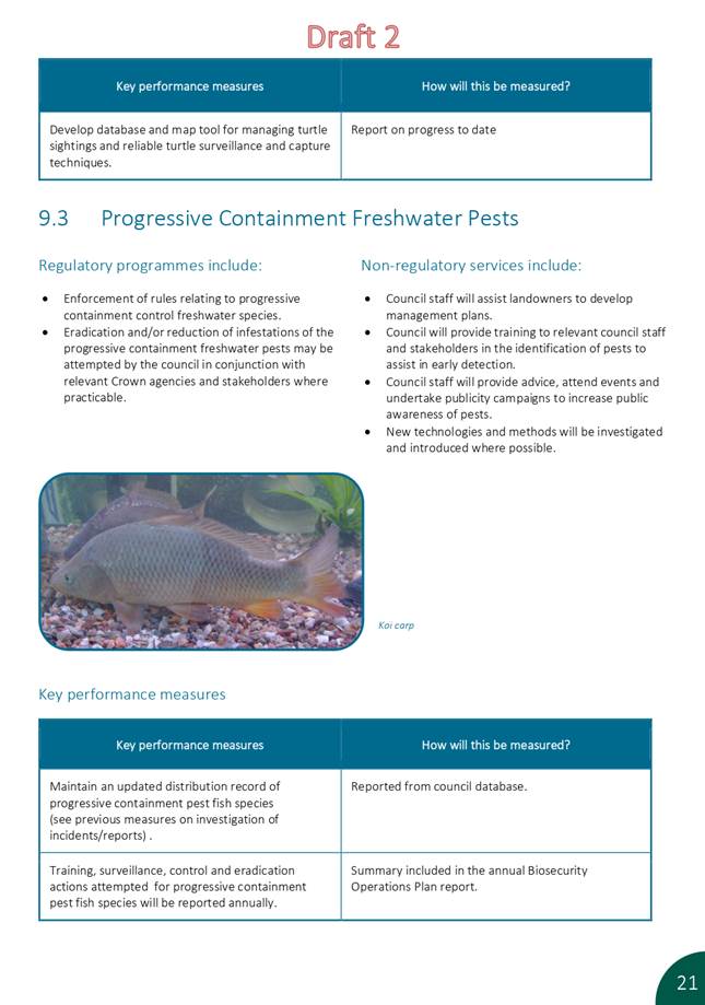
Pest fish surveillance and control
The funding and staff capacity for Biosecurity led pest fish activities remains limited (annual Opex budget for aquatic pests of $20,000/1 FTE), and this was further impacted by the Kai Iwi response as detailed above.
The activities conducted focused on completing surveillance/incursion investigation work for sights where we have received reports of pest fish presence, but the status remains undetermined. This was done in partnership with the Department of Conservation and was also used as a training and upskilling opportunity for DOC and NRC staff and external contractors.
Work has also been underway to re-structure our pest fish database to better reflect the status of reports and management actions. This has also allowed for the development of a new GIS viewer which will improve ongoing management and planning. Data from this year’s surveillance work (netting effort and eDNA analysis) will be used to update that database to provide a better picture of the surveillance and control options and priorities.
The second year of a netting trial at a confirmed koi carp site (unnamed farm dam) was also completed; the goal of this work is to investigate cost and efficacy of sustained netting at small scale sites. Netting is considered to be largely impractical/ineffective for eradication purposes, but there is limited data regarding the efficacy/costs, and consequently it is often still viewed by the community as a legitimate alternative to piscicides/drainage. There are also numerous dune lake sites where piscicide and drainage are not appropriate or realistic options, leaving no other control tools. We are also interested in understanding the efficacy/costs as a suppression tool.
The Biodiversity led pest fish control work, funded through the FIF Fund Dune Lake Project, has focused on pest fish control in two dune lakes: Kapoai and Rototuna, both on the Poutō peninsula.
Lake Kapoai has a large population of tench, and intensive netting at Kapoai aims to interrupt the reproductive success of tench (in 2020: 5,000+ juveniles were removed over 4 days).
Lake Rototuna has previously contained rudd and has been the subject of multiple netting efforts. No rudd have been caught (or seen) at Lake Rototuna since 2019 when NRC contracted the Waikato University to use their electrofishing boat and we caught one large female. Three subsequent netting surveys (2019-2021) have been undertaken and have not detected rudd, which is a promising result.
A joint project is also underway to test the efficacy of eDNA detection technology for pest fish, in static water waterbodies in particular. A total of 20 samples have been taken from 5 lakes around Northland with known pest fish populations. The objective of this work was to investigate the methodology required to produce representative results from a large static waterbody. To date eDNA has primarily been tested in flowing waterbodies where DNA is constantly mixing and moving through the system and larger water volumes can be passed through sample filters.
Most results were as expected (i.e. the target pest fish were detected), although catfish were detected in Lake Waro, Hikurangi, which is potentially a new record/incursion. Some results were not representative, for example, Lake Ōmāpere, where grass carp are present in large numbers but were not picked up in 10 samples taken from various locations around the lake. The results of this work are currently being collated and will be used to inform future eDNA sampling methodology. eDNA holds significant promise for use as a surveillance tool, and if the methodology can be developed to a point of increased reliability it has the potential to significantly improve our ability to detect and confirm new incursions.
Resources
As detailed above, a lack of resource for pest fish focused work is limiting both the control work that can be undertaken on new sites, and more importantly an ability to ‘invest in prevention’ through raising awareness of the impacts of pest fish and finding drivers and mechanisms to encourage behaviour change. In Te Tai Tokerau, we have a significant opportunity to prevent the spread that has occurred in other regions like the Waikato. Pest fish have become a major environmental and community concern in the Waikato region now that they are prevalent and the impacts are widespread, but those regions now have limited options to realistically manage these populations and impacts because of the scale and severity of the problem. Proactive intervention and prevention are key to preventing the same outcomes in Te Tai Tokerau.
Previous LTP new initiative bids have not been successful, and external funding has been sought to help meet this need. A $3.3 million application was submitted to the Ministry for the Environment’s Freshwater Improvement Fund in February 2021. The application outlined a project where the aim would be to raise public awareness of the problems associated with pest fish, such as excess nutrient inputs, predation of taonga species, and reduced habitat quality, by educating local communities through public education events and marae-based workshops. Comprehensive iwi- and hapū-led education packages will be rolled out through marae, Enviroschools, noho taiao, and Te Aho Tū Roa. Educational material (e.g. videos, promotional material) will be created and distributed. The project will attempt to slow the spread of pest fish in Te Tai Tokerau by employing four Kaitiaki Rangers who will be equipped to respond to pest fish incursions, remove grass carp from one iwi-managed lake to allow it to return to a more natural vegetated state, and facilitate the pest fish workshops. One administration and logistics person will also be employed to support this mahi. Successful applications were due to be notified in April, however, due to delays within MFE, notification is now expected in August.
Grass carp
The opportunity to undertake grass carp removals at four lakes arose through the FIF Fund Dune Lake Project. Grass carp are used as an eradication tool for aquatic weed species however they can become an issue if not subsequently reduced in number. Work is underway as part of the FIF Dune Lake Project where a key performance indicator requires “grass carp will be eradicated or removed back to very low numbers from four [dune] lakes.” Grass carp are notoriously difficult to capture, and the focus to date has been on trialling methods, contractors and upskilling staff to determine the control options.
· 800 grass carp were released into Roto-otuauru/Lake Swan on the Poutō Peninsula in 2009 to control two invasive oxygen weeds. Since this time, the fish have denuded the lake of all submerged macrophytes, including those that are native. Through the FIF Dune Lakes project, NRC aims to reduce the total number of grass carp at Roto-otuauru to allow native macrophytes to recolonise and, in time, restore the lake to a more natural state. The depth of this lake makes netting operations more difficult. Following an initial netting operation in October 2020 which removed 36 fish, a second operation was conducted in March 2021, when over four days, 1.2km of nets were used to remove 36 grass carp from Roto-otuauru, bringing the total number of fish removed to 72. Further removal attempts are planned for summer 2021-22.
· 250 grass carp were released into privately-owned Lake Midgely, Ōmāmari, in 2007. In 2014, around 140 grass carp were removed from the lake as they had achieved the desired effect of removing aquatic vegetation. NRC contracted NZ Waterways Restoration Ltd to undertake netting of grass carp over two days in April 2021 where 75 fish were removed, bringing the total number of fish remaining in the lake down to ~15. No further removal attempts are planned due to the low number of fish remaining.
· Lake Waingata is a dune lake on the Poutō peninsula where 168 fish were released in two lots between 1995/6. Grass carp have a life expectancy of 10-15 years in the wild, however, the Waingata fish have now been in the lake for 25 years and fish have been recently sighted, despite the lack of food available to them. eDNA samples were taken in May by NRC and the results confirmed grass carp presence. Planning is underway around how we are best to manage this population of grass carp/whether the numbers still warrant intervention. Netting would require the import of new custom-made nets with a mesh size much larger than what we currently own due to the size of these fish.
· Lake Heather, near Kaitāia, is managed by Ngāi Takoto and the Department of Conservation. 400 grass carp were released here in 2010 to eradicate hornwort and egeria. Ideally, we will visit the lake in summer 2021-22 with the Ngāi Takoto Kaitiaki Rangers and train them to be able to fish their own lake as the aquatic weeds have been eradicated and the lake is now subject to algal blooms without the presence of native aquatic vegetation to filter excess nutrient. The width of the lake is 70-150m therefore will lend itself well to a netting regime as the grass carp nets we own are 80m long.
Nil
Biosecurity and Biodiversity Working Party item: 4.6
16 June 2021
|
TITLE: |
Dune Monitoring Update |
|
ID: |
A1447599 |
|
From: |
Laura Shaft, CoastCare Coordinator and Lisa Forester, Biodiversity Manager |
|
Authorised by Group Manager: |
Jonathan Gibbard, Group Manager - Environmental Services, on 08 June 2021 |
Executive summary/Whakarāpopototanga
This report provides an overview and update on Dune Monitoring.
1. That the report ‘Dune Monitoring Update’ by Lisa Forester, Biodiversity Manager and Laura Shaft, CoastCare Coordinator and dated 26 May 2021, be received.
Background/Tuhinga
In 2016 and 2017 dune transects were set up at eight sites as part of a community dune monitoring programme under development by the Coastal Restoration Trust of New Zealand. CoastCare groups and iwi were involved in workshops demonstrating the methodology. Despite good participation and interest there has been limited take-up from groups wanting to undertake the monitoring independently.
In order to renew interest in this programme and initiate regular dune monitoring the science team and summer interns have assisted the CoastCare team to undertake dune assessments. Over the 2020-21 summer season all eight sites were resurveyed by council staff with assistance from CoastCare groups and iwi at most sites. In addition, new sites were set up and surveyed at Matapouri and Waipu sand spit with Renew School senior science students as part of their year-long study on coastal dune systems.
The surveys followed the guidelines developed by the Coastal Restoration Trust. Transects are placed perpendicular to the coast and the vegetation cover is recorded at 1m intervals. The dune profile is also measured using sampling poles and an inclinometer app along the transect. Data is uploaded to coastal restoration trust website and can be accessed by volunteers, iwi and the public: https://monitoring.coastalrestorationtrust.org.nz
Results indicate that vegetation cover increased at six of the eight sites between 2017 and 2020 (Table 1). A particularly large increase was recorded at Ruakaka Racecourse. This site was previously a vehicle access way that was fenced, shaped and planted with spinifex and pīngao. The vegetation cover at this site has increase from 50% cover to 82%. This demonstrates how quickly a dune can recover with targeted intervention.
Results also indicate that the percentage of native species increased at five of the eight sites (Table 1). The decreases recorded at three sites highlights the importance of ongoing control of pest plants. Weed control is an ongoing issue on dunes, partly because in the foredune and mid-dune area the naturally growing native species are mostly low growing and ground-cover species with no natural canopy to shade out incursion of exotics. The foredune species in particular are also particularly sensitive to incursion of exotic grasses and other species, and left unchecked the native ‘dune-binders’ can be completely displaced, reducing dune function and biodiversity values.
The results of the ongoing surveys will allow us to measure changes in vegetation cover, species composition and the spread of invasive plants over time. This information will help Council to monitor the performance of restoration projects and identify issues for targeted intervention.
Table 1. Change in dune vegetation between 2017 and 2020.
|
Site |
Number of transects |
Change in % vegetation cover (2017-2020) |
Change in % native species (2017-2020) |
|
Ruakaka Racecourse |
2 |
+32.1 |
-8.45 |
|
Ruakaka Surf Club |
5 |
+7.5 |
+17.8 |
|
Pataua |
6 |
-1 |
-6 |
|
Taipa |
7 |
+5 |
+2.42 |
|
Hukatere |
2 |
-6.9 |
+31.8 |
|
Ahipara Kaka St |
4 |
+7.6 |
+6 |
|
Ahipara Mapere Block |
4 |
+12.3 |
-5 |
|
Waipu Cove |
17 |
+7.2 |
+10 |
Drone Images
Drone images were also collected at Taipa and Pataua. Drone images can also be processed to create a digital elevation model providing information about the dune shape and profile (Figure 1). Staff are exploring whether using the drone in addition to the transects will create a fuller picture of the dune health and, if flown regularly, help measure changes in vegetation cover and shoreline over time.

Figure 1. Drone image with 0.25m contours overlain, derived from the digital elevation model.
Fauna Monitoring
Staff had intended to undertake fauna monitoring at four sites in Bream Bay in conjunction with the Patuharakeke Trust Board. This monitoring is on hold pending approvals from the Department of Conservation. Fauna monitoring will include the use of pitfall traps and artificial shelters to survey herpetofauna and invertebrates, and tracking tunnels to survey pests.
Summer 2021/22
Staff intend to survey 10 sites during the 2021/22 summer. Staff will continue to investigate the use of drone images to compliment the survey data.
Nil
Biosecurity and Biodiversity Working Party item: 4.7
16 June 2021
|
TITLE: |
General Updates |
|
ID: |
A1447604 |
|
From: |
Don McKenzie, Biosecurity Manager |
|
Authorised by Group Manager: |
Jonathan Gibbard, Group Manager - Environmental Services, on 08 June 2021 |
Executive summary/Whakarāpopototanga
This report is to provide a general update on the Biosecurity Teams work programmes.
1. That the report ‘General Updates’ by Don McKenzie, Biosecurity Manager and dated 26 May 2021, be received.
2. That the working party note the information.
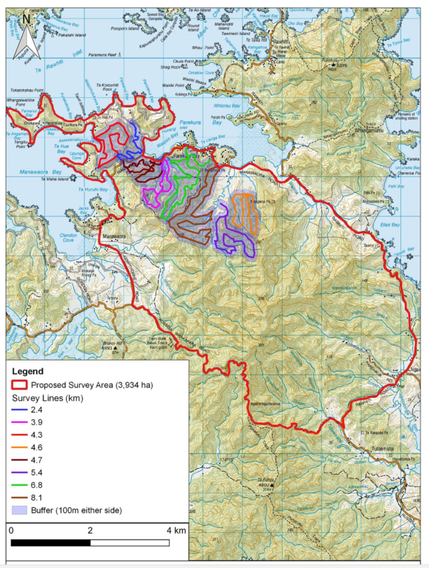
Sika DNA survey
An initial DNA survey has been undertaken as a first step to eradicating sika deer from Russell forest. It is a proof of concept to provide costs and data which can be used to model eradication for the wider Russell forest. The initial survey site provided an appropriate option for a proof of concept as it is known to have a current sika herd and the farm managers are supportive of the approach.
Three expert deer hunters, along with local kaimahi conducted the survey. Over three days they collected sika scat along transect lines across the entire farm at a cost of approximately $25000.
The survey went ahead as planned, and it is looking like a promising option for the total eradication area. The DNA survey results will be available in 3- 4 weeks and the data will be able to tell us the number of individual sika, the sex and the home range of each deer on the property.
NRC is working with the Department of Conservation to plan our next steps, which may also involve removing the goat herd within Russell Forest as the droppings of these animals can be confused with those from deer. This would be completed, before embarking on the wider Russell Forest sika DNA survey and we will be seeking additional funding from the Department for this operation.
Obtaining Wild Animal Control Act powers to carry out control of goats and deer remains a priority particularly in the event a landowner refuses access. This issue is ongoing, and staff continue to work with the department to resolve the issues surrounding the killing of wild animals on private land.
Wider Northland Deer Programme
Staff are preparing to recruit a Biosecurity Specialist – Feral Deer in the new year, who will lead the eradication programme and work closely with the Northland deer farming community to minimise deer escapes.
DOC, OSPRI, MPI, NRC and a Northland deer farm representative recently met to address the issues surrounding deer farms in Northland and agreed that a collective approach is needed to address these issues together in order to build trust and relationships with the deer farming community, while at the same time providing clear expectations around fencing, tagging and registration. The option of taking a ‘clean slate’ approach was discussed, which would mean DOC revoking all deer farm permits and re-issuing them to farms that meet fencing standards, along with NAIT compliance with registration/tagging standards. The next meeting is expected in July, where we will discuss formalising the group.
Map of sika eradication area, and proof of concept survey lines.
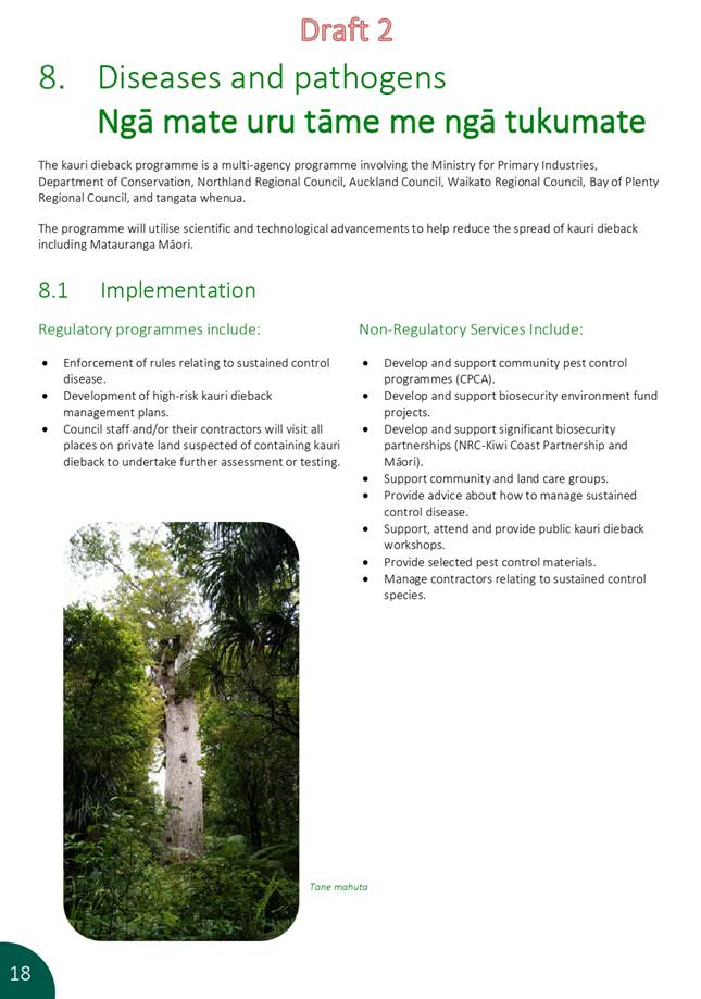
Kauri Dieback Programme
On the ground follow up to aerial surveillance
This work is nearing completion on private land with 309 sites involved, however we have 15 sites that we have been unable to contact the landowner and 25 sites where landowners have denied access for a variety of reasons. Talks with these owners are continuing and we have a dedicated Biosecurity Officer working to ensure these properties don’t present undue biosecurity risks in terms of kauri dieback spread.
Management Plans
We have provided 41 mitigation advice notices to landowners with sample results showing no disease presence and we continue to develop management plans with landowners who have positive results.
Soil sampling
We have sampled 11 properties via requests from the public and have further landowner requests to conduct site visits and these will be actioned in the spring when weather conditions are more suitable. In addition, we continue to sample aerial surveillance sites and other areas to better inform management decisions e.g. sampling Rawhiti Tracks
Engagement
A Kauri Protection Education Programme across Northlands schools is underway due to the recently appointed engagement officer. To date six education workshops have been carried out over Northland schools, and there are 2-3 schools a week being visited this term. Uptake and feedback has been very positive. Eight Kauri Protection workshops with community groups, trappers, hapu have been carried out this year with more planned.
The team are running a campaign with the Northland Pig Hunting Club to better connect with the hunting community and have also provided hygiene kits for an upcoming hunting competition in Pawarenga and will attend other hunting events during the winter.
Kauri Mitigation Project
Kauri Mountain Trail track upgrade is complete. Onekainga Track physical works commenced end of May and good progress is being made. Work has started at the Whananaki North Road end through Kauri areas first. Work will continue on this track until winter kicks in. The crews will move north to the 3 jobs which have been scheduled near Waipapa/Kerikeri for winter.
Marine biosecurity
Opua Sabella eradication
Diver removal work was conducted in discrete, targeted periods between November 2020 and June 2021. Results indicate that there are no or very few Sabella located on the seafloor between structures (most likely due to unsuitable habitat structure), and we are now able to target current and future removal efforts more efficiently to the most suitable habitats and locations. The data also indicates it is highly likely that the majority of the remaining adult population have been removed. The task ahead is now to steadily and systemically remove the remaining population of recent recruits which in turn will drive the size class structure downwards until the population is eradicated or so sparsely distributed that it collapses. Funding is in place for the continuation of this project and we have a good understanding of how to maximise success, providing no new incursions occur. Additional hull surveillance will be conducted over the coming years to bolster our efforts at keeping new incidents out of the Bay of Islands and we are considering ways to obtain locally meaningful growth rate information alongside the eradication work to ensure our efforts are as efficient as possible.
Clean Hull Plan
Development of the Clean Hull Plan has progressed considerably in the last quarter with drafts either complete or almost complete for the Cost Benefit Analysis and the Cost Allocation Analysis, as well as a range of complimentary pieces of work including the drafting of a Multi-Agency agreement. Pre-engagement with treaty partners and key stakeholders is underway and the project team are collating and considering the feedback to identify issues and opportunities as well as any implications for the direction of the plan.
The team have progressed further thinking around what it looks like to use the proposed plan as a stepping stone to a national model and are managing alignment by considering the treatment of existing rules in regional pest or pathway management plans. Further advice on a requirement for biosecurity risk management plans for high risk structures/activities and a briefing note on the identified barrier of ‘insufficient vessel cleaning infrastructure in NZ’ are being prepared. Decision papers for councils are being drafted as information is finalised, and planning is underway in anticipation of formal consultation.
Wilding conifers
Northland has been funded a total of $1.7M in the last 12 months for wilding pine control by the MPI led programme and works have included the eradication of pines, mostly Pinus radiata but also Pinus pinaster or maritime pine from more than 41 sites across Northland. These sites where pines have invaded wetlands, gumlands, coastal margins, dune lakes and shrublands in some cases dominating natural cover and affecting waterways. Employment figures vary across the year, in May 65 workers were registered with the project; during June this has reduced to 32 as the financial year come to an end. Staff have developed positive working relationships with hapū, whanau and iwi and have been working closely with the MPI wilding conifer team on future funding. We are hopeful that funding for the next 2 years to extend the national programme to Northland will be confirmed over the coming weeks.
Predator Free 2050
Predator Free 2050 is an ambitious goal set in 2016 to make Aotearoa New Zealand free from three introduced predators that cause the greatest harm to our native wildlife: possums, mustelids (Ferrets, Stoats, Weasels) and rats by 2050.
The Predator Free 2050 Strategy was launched in March 2020 which sets a common and shared direction for how the Predator Free 2050 goal could be achieved. The Strategy proposed a collaborative, collective approach towards achieving Predator Free 2050, whilst allowing individual agencies, organisations and community groups to continue to undertake the work that they do best.
The Strategy has three key phases of work “Mobilise, Innovate and Accelerate”
· Mobilise – to engage people and resources
· Innovate – create or improve predator eradication tools and methods for across rural, urban and natural landscapes, and
· Accelerate – rapidly deploy and effectively manage predators throughout the country.
To organise delivery of the Predator Free 2050 Strategy, six pathways have been identified. These pathways help rationalise and focus the work required to achieve Predator Free 2050 (PF2050):
1. Mā ngā whānau, mā ngā hapū, mā ngā iwi e whakatau tō rātou kaitiakitanga Whānau, hapū and iwi expressing kaitiakitanga
2. Me whakaohooho, me whakamana ngā hapori kia mahi i te mahi Communities taking action
3. Te whakatinana i ngā ture me ngā momo kaupapa here e tika ana mō te kaupapa Supporting the kaupapa through legislation and policy
4. Te mātauranga, te mahi auaha, te whakapai Advancing our knowledge, innovation and improvement
5. He aronui, he aromataiwai, he aromātai i te rerekētanga Measuring and assessing the difference we make
6. Te nuku atu i te pupuru i te maha o te kaikonihi kia iti, ki te ara haepapa pūmau Moving from sustained predator control to eradication.
The Predator Free 5-year Action Plan works alongside the strategy which focuses on the work required over the next 5 years (2020–2025) and outlines key near-term outcomes within the six pathways, with a focus on how this work contributes to the overarching strategy of ‘mobilising, innovating and accelerating to deliver a predator free New Zealand by 2050’.
One of the milestones of the action plan is: Coordination between iwi, councils, community groups and others enables shared regional plans to be developed. Whānau, hapū and iwi, community groups and non-governmental environmental organisations, local authorities, DOC and others will come together to stocktake work within each region and develop 5-year action plans to set out how each region will work towards PF2050 objectives. The collaborations will help clarify accountabilities, roles and responsibilities for this work. Northland and Southland have been selected as the first two regions to get this process underway.
Predator Free Te Tai Tokerau – Five Year Action Plan
Council staff have been working closely alongside the Department of Conservation to progress the development of a Predator Free Taitokerau five-year action plan. Staff have had ongoing discussions over the last 9 months to begin developing a regional five-year action plan for Northland. The development has included planning workshops involving community groups and agencies from around the region. This plan will help guide where investment is needed to help progress towards achieving PF2050.
Predator Free Whangarei
Predator Free Whangārei is a collaborative five year project that builds on over 20 years of dedicated and successful community predator control in the Whangārei area.
The seed for this project was planted over three years ago, with a conversation between local community groups and agencies working together on predator control. After initial conversations with Predator Free 2050 Limited (PF2050 Ltd) in 2018 and many months of discussion and development, funding for the project was approved in March 2020
The Whangarei Predator Free programme has several objectives, these include:
· Completely remove possums from the Whangārei Heads Peninsula (9000ha)
· Intensively control mustelids between Whangārei, Tutukaka and Te Whara / Bream Head
· Intensively control rats in high priority sites
· Intensively control possums between Whangārei and Pārua Bay to prevent their dispersal into Whangārei Heads
· Develop an urban predator control programme in Whangārei City (Tiakina Whangārei)
Much of the work to date has been about setting the foundations of the project, including many hours of community hui and engagement. New systems have been developed to enable the project to start, including developing online tools to manage customer relationships, monitor progress towards eradication and enable easy reporting back to funders and project partners.
A project steering group has been established to help oversee the project and ensure project partners are well connected and engaged.
Council now has a Predator Free Whangārei Team of five, with additional field staff and contractors needed over the coming months as eradication work begins in October 2021.
Predator Free Bay of Islands
Northland Regional Council on behalf of Bay of Islands iwi, hapū, landowners, community landcare groups, organisations, and agencies has successfully secured funds of $4M from Predator Free 2050 Ltd to develop a collaborative predator free programme in the Bay of Islands.
Predator Free Bay of Islands is a proposed landscape scale, community led predator control and eradication project working alongside existing pest control programmes across the three main peninsulas within the Bay of Islands (Purerua Peninsula, Russell Peninsula and Cape Brett/Rakaumangamanga.
Over the coming months the project will work alongside iwi and hapū, landowners, community groups and agencies to engage with those who are keen to be involved. This will include developing a collaborative project plan, and feasibility investigation to guide where eradication objectives can be achieved, followed by the development of technical eradication plans and then implementation.
Staff anticipate that the delivery of the Bay of Islands project will be different from the Whangārei project, with Iwi/hapū keen to be more involved in the delivery of the project. Council is in the process of advertising for two roles to help support and initiate the project.
Tiakina Whangarei
Tiakina Whangārei is a community-led urban initiative helping people connect with their environment through conservation activities, while supporting existing mahi, to protect and enhance Whangārei’s native biodiversity. Planning for the initiative started in 2018, and was officially launched in August 2019. Funding for Tiakina Whangārei was sucured through Councils Long Term Plan (2018-28). Tiakina Whangarei is closely connected and an essential component of the Predator Free Whangarei programme.
The primary focus of Tiakina Whangārei is to initiate, promote, and support mammalian predator control activities by Whangārei residents to protect native biodiversity; however, the initative also has a wider mandate to enhance the connection residents have with their environment through conservation activities to increase environmental awareness and help build community cohesion.
As such, Tiakina Whangārei aims to deliver on objectives across three Core Work Streams:
1. Increase community cohesiveness, ecological knowledge, and social wellbeing
2. Encourage kaitiakitanga/guardianship of the environment; and
3. Protect and enhance native biodiversity within Whangārei.
Tiakina Whangārei is now in its 2nd year and council staff are undertaking a review of the project and how it is being delivered. There is a growing demand for support through Tiakina Whangārei which needs additional resources and staff time, along with new partnerships with other organisations. Staff are in discussion with Whangārei District Council regarding a potential project partnership to improve biodiversity objectives in and around urban Whangārei.
Nil