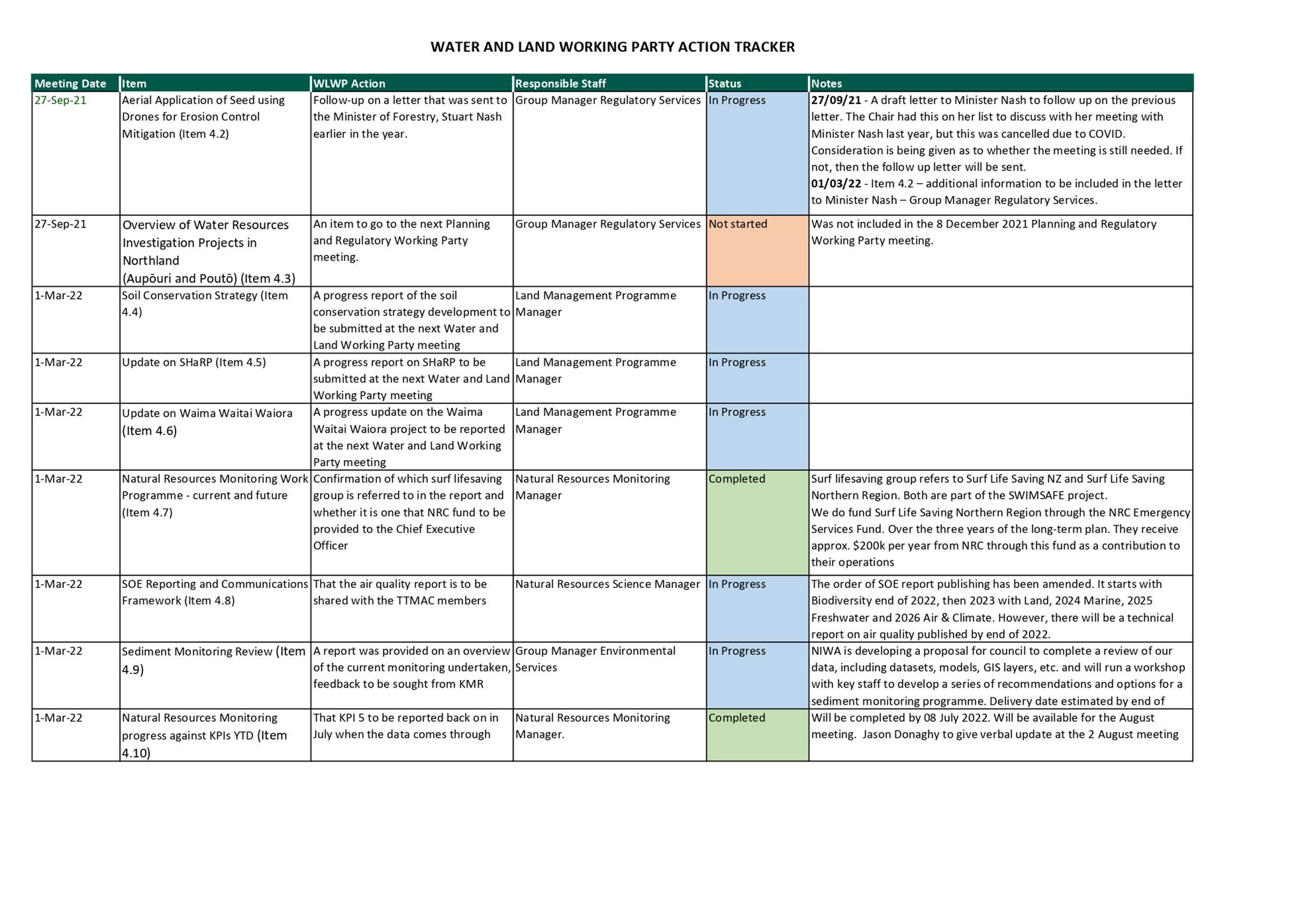
|
Water and Land Working Party Tuesday 2 August 2022 at 10.00am
|
|
|
|
|

|
Water and Land Working Party Tuesday 2 August 2022 at 10.00am
|
|
|
|
|
Water and Land Working Party
2 August 2022
Water and Land Working Party Agenda
Meeting to be held in the Council Chamber
36 Water Street, Whangārei
on Tuesday 2 August 2022, commencing at 10.00am
Please note: working parties and working groups carry NO formal decision-making delegations from council. The purpose of the working party/group is to carry out preparatory work and discussions prior to taking matters to the full council for formal consideration and decision-making. Working party/group meetings are open to the public to attend (unless there are specific grounds under LGOIMA for the public to be excluded).
MEMBERSHIP OF THE Water and Land Working Party
Chairperson, Councillor Justin Blaikie
|
Councillor Jack Craw |
Councillor Amy Macdonald |
Councillor Marty Robinson |
|
Councillor Joce Yeoman |
Ex-Officio Penny Smart |
TTMAC Representative Janelle Beazley |
|
TTMAC Representative Georgina Connelly |
TTMAC Representative Waimarie Kingi |
TTMAC Representative Mira Norris |
|
TTMAC Representative Alan Riwaka |
|
|
KARAKIA
RĪMITI (ITEM) Page
1.0 Ngā Mahi Whakapai/Housekeeping
2.0 Ngā Whakapahā/apologies
3.0 Ngā Whakapuakanga/declarations of conflicts of interest
4.1 Record of Actions – 1 March 2022 3
4.2 Receipt of Action Sheet 8
4.3 Update on Lake Omapere water quality and MOU with Lake O Trust 10
4.4 Harbour and Estuary ecological monitoring programme and opportunities to expand 11
4.5 Update on implementation of Network Review 18
4.6 Update of SOE sediment monitoring programme progress 19
4.7 SWIMSAFE Trial Update 20
4.8 Sharp and WWW programme update 23
Water and Land Working Party item: 4.1
2 August 2022
|
TITLE: |
Record of Actions – 1 March 2022 |
|
From: |
Erica Wade, Personal Assistant - Environmental Services |
|
Authorised by Group Manager/s: |
Ben Lee, Planning and Policy Manager, on |
Whakarāpopototanga / Executive summary
The purpose of this report is to present the Record of Actions of the last meeting (attached) held on 1 March 2022 for review by the meeting.
Attachments/Ngā tapirihanga
Attachment 1: Record of Actions - 1
March 2022 ⇩ ![]()
2 August 2022
|
TITLE: |
Receipt of Action Sheet |
|
From: |
Erica Wade, Personal Assistant - Environmental Services |
|
Authorised by Group Manager/s: |
Ben Lee, Planning and Policy Manager, on |
Whakarāpopototanga / Executive summary
The purpose of this report is to enable the meeting to receive the current action sheet.
That the action sheet be received.
Attachments/Ngā tapirihanga
Attachment 1: Action Tracker ⇩ ![]()
Water and Land Working Party item: 4.3
2 August 2022
|
TITLE: |
Update on Lake Omapere water quality and MOU with Lake O Trust |
|
From: |
Jason Donaghy, Natural Resources Monitoring Manager |
|
Authorised by Group Manager/s: |
Ben Lee, Planning and Policy Manager, on |
Whakarāpopototanga / Executive summary
The draft MOU that was developed in 2018 between Council and the LOT was discussed, it agreed for the LOT to take the document to a full trust meeting for review as a potential starting point for building a partnership. Council is currently waiting for LOT to come back with the review outcome, if more information becomes available post the agenda deadline it will be provided verbally at the meeting on 02 August 2022.
1. No action required
Background/Tuhinga
Nil
Nil
Water and Land Working Party item: 4.4
2 August 2022
|
TITLE: |
Harbour and Estuary ecological monitoring programme and opportunities to expand |
|
From: |
Richard Griffiths, Resource Scientist Coastal and Jean-Charles Perquin, Natural Resource Science Manager |
|
Authorised by Group Manager/s: |
Ben Lee, Planning and Policy Manager, on |
Whakarāpopototanga / Executive summary
Following Cr Blaikie request on providing options for coastal ecological baseline surveys of Northland’s harbours and estuaries, this short report provides some background on council’s existing monitoring and associated methodologies including intertidal and subtidal surveys. The feasibility of each type of survey with associated limitations and costs are also presented.
1. There is no recommended action
Background/Tuhinga
Cr. Blaikie requested a briefing on options for ecological baseline surveys of Northland’s harbours and estuaries.
Existing monitoring
1. National Estuary Monitoring Protocol
Council has implemented Estuary Monitoring Programmes in the Whangārei Harbour, Kerikeri Inlet and Ruakaka Estuary. The monitoring methods follow the National Estuary Monitoring Protocol (Robertson et al. 2002), which was developed by Cawthron for use by regional councils. These programmes involve sampling the physical and chemical properties of the sediment, and the ecological communities of representative intertidal habitats.
These programmes assess the health of representative ‘sentinel’ sites and provide baseline data, which can be used to track changes in the health of these sites over time. These sites were initially sampled annually (2008-2011) to determine the baseline conditions and the natural variability of the ecological communities. Since 2012(?) they have been sampled every two years.
Between 2012 and 2016 Council also undertook ecological surveys of five estuaries to provide baseline data in support of Council work with stakeholder groups in ‘priority’ catchments. The five estuaries surveyed were Whangārei (2012), Waitangi (2013), Kaipara (2014), Ngunguru (2016) and Mangonui (2016). Council intends to resurvey these estuaries every ten years and this year has resurveyed Whangārei Harbour.
2. Remotely piloted aircraft system (RPAS) survey and habitat assessment of Ruakaka Estuary
In 2019, Council undertook a pilot project to investigate the use of a RPAS (drone) to facilitate rapid estuary-scale habitat surveys.
3. Seagrass Mapping
In 2015, Council used aerial images to hand digitalise seagrass habitat across the whole Northland Region https://localmaps.nrc.govt.nz/LocalMapsGallery/ . The layer was developed to assist with the identification of Significant Ecological Areas as part of the development of the new Regional Plan.
4. Saltmarsh and Mangrove Mapping
In 2020, Council utilised remote sensing methods to map saltmarsh and mangrove habitat for the entire Northland Region. These layers are publicly available on our website and are presented in 19 worksheets which combined, encompass the Northland region. https://localmaps.nrc.govt.nz/LocalMapsGallery/
5. Significant Ecological Area Surveys
In 2021, Council undertook surveys of Significant Ecological Areas, identified in the Proposed Regional Plan, in Waipū Estuary, with Patuharakeke and in Mangawhai Harbour with Te Uri o Hau.
6. Ipipiri Survey
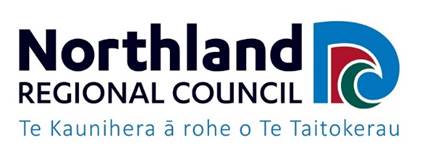
In 2020/2021 Council was involved in a subtidal ecological survey of the semi-sheltered waters located between the central islands of the eastern Bay of Islands and the Rāwhiti channel (Ipipiiri Platform). This project was developed by local researchers and Ngati Kuta, and supported by Council and NIWA.
Drop cameras, under water video, drone, and multibeam echosounder were used to survey the area. Subtidal seagrass beds and extensive beds of turf algae were identified around the islands, extending to depths of 12 metres and the information collected is being used to develop habitat maps of the area.
Figure 1. Habitat map created from the Ipipiri survey in the eastern Bay of Islands.
Methods for Ecological Surveys
1. Intertidal surveys
Council staff have the capability and experience to undertake intertidal ecological surveys of other estuaries in Northland. Council could establish National Estuary Monitoring sites in additional estuaries or conduct additional one-off broadscale ecological surveys in a new estuary. The main limitation to expanding the progarmme is the laboratory costs of analysing ecological samples and staff resources. Council’s Water Quality Field Operations Team and Council’s Coastal Scientist have limited capacity to undertake any additional monitoring.
Broadscale habitat surveys and SEA assessments could be undertaken without the need for expensive analysis of ecological samples, but these typically require more staff resources.
2. Subtidal surveys
Council has developed internal skills and experience of undertaking subtidal ecological surveys through participation in the recent subtidal survey of the ‘Ipipiri platform’ in the eastern Bay of Islands. Council staff has the expertise and experience to undertake surveys using underwater video, drop cameras, baited underwater video systems and multibeam echosounder systems. One limitation is the availability of staff resources. Council’s Water Quality Field Operations Team and Council’s Coastal Scientist have limited capacity to undertake any additional monitoring.
3. Subtidal survey equipment
Council has its own tethered underwater video, a multibeam echosounder system and a baited underwater video (BRUV) system. Council could easily construct a drop camera system for inshore subtidal surveys.
Underwater video
Council owns a Deep Trekker DTX 2 under water submersible with 4K Video camera and external lighting. The submersible is operated via a controller on a 150m tether. This submersible could be used to collect high quality images of the seabed, providing information about the substrate and subtidal habitat features such as turf algae, seagrass, rhodolith beds, scallop beds and horse mussel beds. One limitation of the underwater video is the speed at which the submersible can traverse the seafloor, limiting the size of the area that can be surveyed each day.
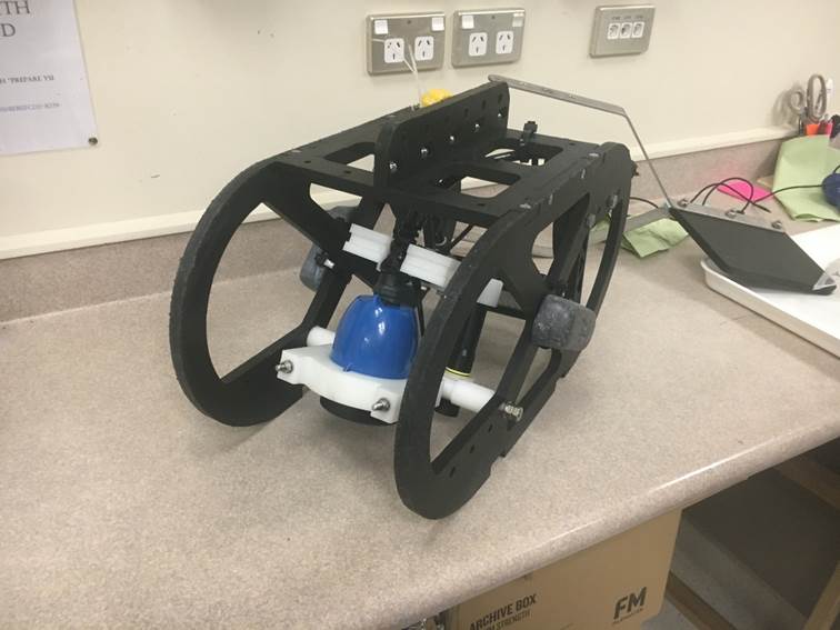
Plate 1. Underwater video used in the Ipipiri survey.
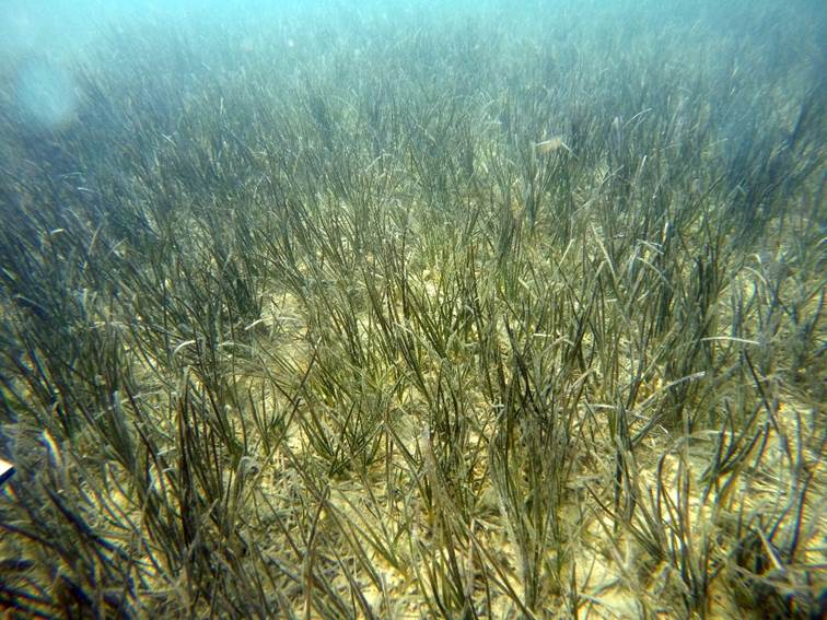
Plate 2. Subtidal seagrass beds, captured during the Ipipiri survey.
Baited remote underwater video (BRUV) system
Baited remote underwater video systems (BRUV), comprise a tripod with an underwater video and a bait station to attract fish. The bait attracts fish into the view of the underwater camera, which provides information about fish diversity, abundance, and behaviour.
BRUV systems are typically deployed for a 60-minute soak time, so this limits the number of sites that can be sampled each day, although this could be increased by operating two systems at the same time.
Consideration of the timing of BRUV surveys is crucial, as some species may use different areas of an estuary at different life stages or may make seasonal migrations. Some species will also have different feeding patterns and diets depending on ontogenetic stage and season.
Drop camera
A drop camera set up is essentially just an underwater camera on a tripod with underwater lighting. The system is deployed from a vessel and dropped to the seafloor to collect images of the seabed. More than one camera can be deployed on the tripod and set at different angles to collect different perspectives. The main advantage of a drop camera is the speed of deployment which means a relatively large area can be covered. Ideally the drop camera would be used in combination with another survey method. The drop camera could be used initially to identify key features or habitats, which could then be surveyed in more detail with an underwater video.
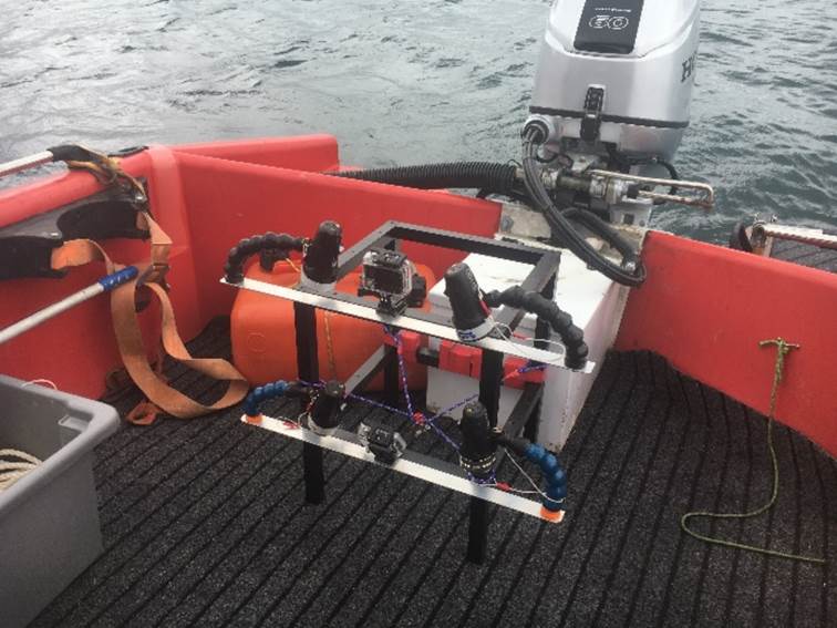
Plate 3. Drop camera set up with two GoPros and underwater lighting used in the Ipipiri survey.
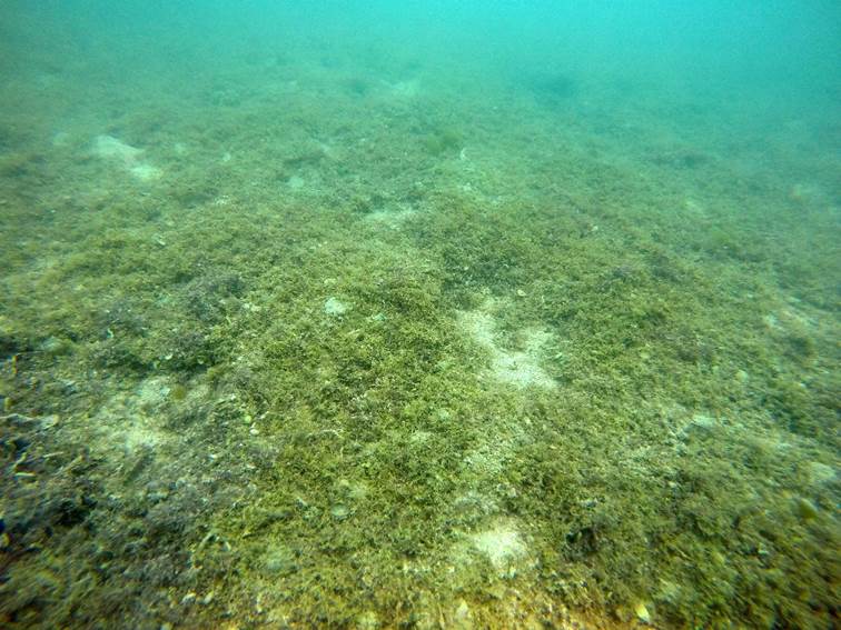
Plate 4. Underwater video image of rare subtidal turf algae beds captured during the Ipipiri survey.
Multibeam echosounder system
Council has a WASSP S3 multibeam echo sounder system that can be used to produce bathymetry data and imagery of the seafloor. The bathymetry data can be used to create maps and models of the shape and depth of the seafloor. The strength of the return signal (backscatter) can also be used to produce images of the seafloor and detect features and habitats. Again, a major limitation is the speed at which the vessel can travel at when operating the multibeam system and the swath width. The swath width depends on the water depth and is typically about 5.5 times the water depth. This means that in relatively shallow environments like estuaries the vessel needs to keep tracks close together to achieve complete coverage of the seafloor. This obviously limits the size of the area that can be surveyed.
4. Other subtidal survey techniques
Other options include, collecting ecological samples using a ponor grab, dive surveys and the use of environmental DNA (eDNA) sampling. Ecological core samples are time consuming to collect and expensive to analyse but do provide high quality data about the ecological communities living in the sediment. Dive surveys can be used to collect underwater video and collect ecological samples. They are expensive and require more health and safety considerations than using an underwater video. eDNA sampling utilises traces of genetic material left behind as living things, such as fish, move through the water column. eDNA has the potential to revolutionise ecological sampling but the science is still in its infancy and therefore would need to be utilised alongside other survey techniques.
Limiting factors
The main limitation to undertaking subtidal surveys is staff resources. Undertaking a subtidal survey requires a maritime vessel and skipper and at least two staff members to deploy equipment safely and efficiently. In addition, underwater ecological surveys typically produce a large amount of images and video footage, which take a significant amount of time to analyse and characterise to produce a meaningful output like a habitat map. It is important to note that Council’s existing capacity to undertake any further monitoring is limited.
Indicative costs
Indicative staff time and costs are provided below for a typical small survey (small estuary or 5 study areas) and a typical larger survey (medium sized estuary or 10 study areas). These costs are based on the staff charge rates in Council’s User Fees and Charges 2021/22. These estimates only include the time and cost to undertake the fieldwork component of any survey. Additional time is required to analyse and interpret the data. Depending on the volume of data and images collected this can be considerable, this was not accounted for in this estimate. Other staff resources, such as the data team and GIS team are also required to help with data storage and processing, this was not accounted for in this estimate.
Small survey (5 days survey):
|
|
Hours |
Unit cost |
Total cost |
|
Maritime vessel |
40 |
$283.48 |
$11,339.2 |
|
Maritime skipper |
40 |
$152 |
$6,080 |
|
Resource scientist |
48 |
$152 |
$7,296 |
|
Field technician |
48 |
$77 |
$3,696 |
|
Total |
|
|
$28,411.2 |
Larger survey (10-day survey):
|
|
Hours |
Unit cost |
Total cost |
|
Maritime vessel |
80 |
$283.48 |
$22,678.4 |
|
Maritime skipper |
80 |
$152 |
$12,160 |
|
Resource scientist |
88 |
$4152 |
$13,376 |
|
Field technician |
88 |
$77 |
$6776 |
|
Total |
|
|
$54,990.4 |
Additional costs:
· Sediment sample analysed for nutrient concentrations, sediment grain size and metal contaminants = $201 per sample
· Biological core sample = $420 per sample
· eDNA analysis = $160 per sample
Nil
Water and Land Working Party item: 4.5
2 August 2022
|
Update on implementation of Network Review |
|
|
From: |
Jason Donaghy, Natural Resources Monitoring Manager |
|
Authorised by Group Manager/s: |
Ben Lee, Planning and Policy Manager, on |
Whakarāpopototanga / Executive summary
Councils environmental monitoring network was reviewed by the Natural Resources Science team to ensure it was fit and purpose.
The paper provides a brief update on progress as the project has entered the implementation phase which is being led by the Coastal Water Quality team:
· Water Quality Sampling Network: this program is behind schedule. Engagement with Tangata Whenua in five catchments is taking longer than expected. The five catchments are in the Far North, Herekino and Bay of Islands.
· Lakes Sampling Network: this program is ahead of schedule, the sites are operational with processes under development regarding data management.
· River flow Network: this program is on schedule, there are three sites planned for the 2021/22 financial year.
1. No action required
Background/Tuhinga
Not applicable.
Nil
Water and Land Working Party item: 4.6
2 August 2022
|
TITLE: |
Update of SOE sediment monitoring programme progress |
|
From: |
Jean-Charles Perquin, Natural Resource Science Manager |
|
Authorised by Group Manager/s: |
Ben Lee, Planning and Policy Manager, on |
Whakarāpopototanga / Executive summary
This is a short update to the Water and Land Working Party on the progress of Council’s sediment monitoring review led by Council’s science team. The review is two fold:
1. Stage 1: defining current state and workshop with key NRC staff. This step will consist of collecting all information and data council holds on sediment, including datasets, research studies, models, etc. Use this stocktake to build a structured workshop which will primarily focus on developing a tight and clear scope to define NRC objectives for establishing a regional sediment monitoring programme.
2. Stage 2: developing a sediment monitoring programme for Northland. Utilise NIWA expertise and experience to shape recommendations and options for NRC sediment monitoring programme through in-depth analysis of Stage 1 outputs aiming to meet all objectives defined in Stage 1. All outputs will be captured in a report.
This review will involve key NRC staff including policy, land management, science, monitoring; and is closely related to the Land Management soil conservation strategy in development. NRC science team has engaged NIWA to develop a proposal which is expected to be delivered by mid-August 2022. The overall project delivery is at this stage expected to be delivered by end of 2022 which would coincide with the delivery timeframe of the soil conservation strategy. The established monitoring plan will then be implemented by the monitoring team in conjunction with the science team.
1. There is no recommended action
Background/Tuhinga
Not applicable.
Nil
Water and Land Working Party item: 4.7
2 August 2022
|
TITLE: |
|
|
From: |
Jason Donaghy, Natural Resources Monitoring Manager |
|
Authorised by Group Manager/s: |
Ben Lee, Planning and Policy Manager, on |
Whakarāpopototanga / Executive summary
Safeswim is a predicative water quality tool trialled by the Natural Resources Coastal and Water Quality team. The paper provides an update as the project is now entering the implementation and communication phase. Communication of the system is the key theme of the paper.
1. No action required.
Background/Tuhinga
System overview:
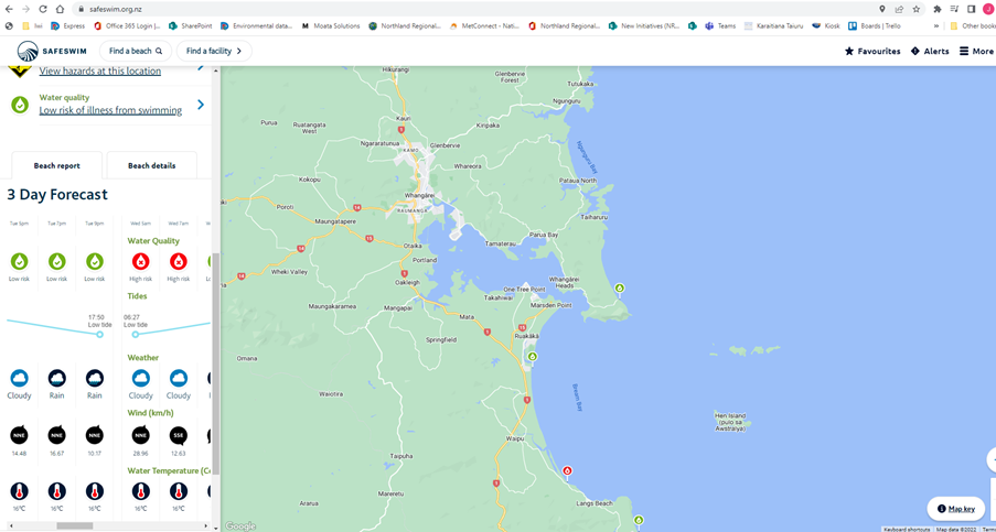
The Safeswim system was developed by Auckland Council and recently adopted by Surf Life Saving New Zealand as their main information platform. The system uses a combination of modelled and measured rainfall to predict water quality at set locations in real time across Te Tai Tokerau.
Each location in Safeswim has its own site-specific model. Independent audits of Safeswim completed by Audit New Zealand in 2020 and 2021 found that a random sample of Safeswim’s water quality predictions in Auckland were 89% accurate and concluded that no changes to the system were required
Communication:
The Safeswim system operates all year round and provides a warning to swimmers three days in advance. The information warning swimmers of potential risk will be displayed on the Safeswim platform and linked to the Northland Regional Council website with data also appearing on the Land & Air & Water Aotearoa website (LAWA). The system is a significant step forward as currently routine water samples are taken by council staff and sent to a laboratory with results logged on the council website and LAWA days later. Routine sampling doesn’t help swimmers wanting to swim on a particular day, for example if sampling is completed every week on Wednesday and a family wants to go swimming on a Saturday, a lot can happen between the sample day and swim day. Predictive modelling resolves this problem by providing information every day real-time. Routine monitoring will be required for a period of time to check against what the model is predicting, once the model is performing well the routine visits will be dropped or redeployed to another critical area.
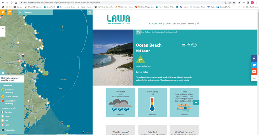
Regarding LAWA and risk to swimming at swimming sites, LAWA looks at the latest results (2-3 days old) and provides a colour marker on a map, green for good, red for bad. LAWA also looks back over each summer period and provides long term grades. The platform was designed to provide the public a sense of the long-term water quality at locations in their region. It was not designed as an operational real time data platform, which is why flood forecasting data is not displayed on the platform, this is managed by each council via their own communication channels and websites. Although some of the Safeswim data will be sent to the LAWA website. The Safeswim platform offers a better user experience for people planning swimming trips as shown below.
https://www.lawa.org.nz/explore-data/northland-region/swimming/ocean-beach-at-mid-beach/swimsite
A communication plan is being developed, the system will be promoted as the platform to use regarding swimming and beach safety. Safeswim offers the predicative capability that LAWA does not.
The intent is for Safeswim to sit alongside LAWA. For long term water quality trends go to LAWA, for what is happening in the now and the next few days go to Safeswim. Council supports LAWA and will continue to do so into the future. This is a shift from the status quo, currently only Auckland and Northland have taken this approach, which was recognised by the World Health Organisation and mentioned in an online article last year on the Auckland Council website:
“For the first time, WHO recommends the use of predictive models to provide real-time water quality information and it includes Safeswim as a case study of how to do this. An innovative, world-class programme, Safeswim has led the way providing real-time forecasts of water quality, and up-to-the-minute advice on swimming conditions at over 115 sites around the region since its inception in the summer of 2017”. (Auckland Council website, July 2021, https://ourauckland.aucklandcouncil.govt.nz/news/2021/07/safeswim-spotlighted-on-global-stage/)
Nil
Water and Land Working Party item: 4.8
2 August 2022
|
TITLE: |
Sharp and WWW programme update |
|
From: |
Ruben Wylie, Land Management Programme Manager |
|
Authorised by Group Manager/s: |
Ben Lee, Planning and Policy Manager, on |
Whakarāpopototanga / Executive summary
The Waima Waitai Waiora (WWW) project is a five-year project that commenced in 2018 and is due to end at the conclusion of the 2022 calendar year. The project is co-funded by the Ministry for the Environment. The Sustainable Hill Country and Regional Priorities programme (SHaRP) is a four-year programme co-funded by Northand Regional Council and the Ministry for Primary Industries. The programme commenced in 2019 and is set to conclude at the end of the 2022/2023 financial year
This report provides an update on both projects.
1. A progress update on the WWW and SHaRP projects will be reported to the Water and Land Working part at its next quarterly meeting.
The Waima Waitai Waiora
The Waima Waitai Waiora (WWW) project is a five-year project that commenced in 2018. The project is co-funded by the Ministry for the Environment and is presently in its final year. The WWW project represents the culmination of a partnership between mana whenua within the Northern Wairoa catchment, community organisations and NRC, and the arrangement has given rise to some significant advancements in the way in which NRC works with mana whenua. Partnering with mana whenua and both national and local authorities has led to more robust decision-making processes, more meaningful outcomes, and continued support for the kaupapa from local residents.
The WWW project is focused on delivering several key projects with its partner groups. Key project tasks include supporting landowners to fence off waterways and plant a total of 370,000 plants over the five-year project timeframe. This report will summarise work that has been completed over the first half of the 2022 calendar year, and identify key tasks associated with the six months of the project.
Key highlights over the 2022 calendar year.
· Te Kawa Waiora research report has been finalised and launched and is now available via the Reconnecting Northland website. The purpose of the research was: “To enable iwi/hapū/whānau/marae (tangata whenua) of the river to conduct research concerning issues of importance to them and as the basis by which their contribution to raising the health, wellbeing, and mauri of the Wairoa River can be achieved”.
· Planting plans for the 2022 planting season will facilitate the planting of 70,000 native plants.
· Alongside the plants, over 7,630 meters of riparian fencing is to be established on farms to provide protection for the planting.
· Over $36,000 was raised this year via the partnership’s collaboration with the Sustainable Business Network’s Million Metres Streams Project, with funds being donated by various businesses, community groups, and even some generous individual donors.
· Despite Covid-19 restrictions, a number of successful events were held by WWW and their partners, including the Te Kawa Waiora launch event, freshwater monitoring, and an onsite field day at Hiruiki Maunga. The community day at Hiruiki was an opportunity to share aspirations and knowledge around undertaking ecological restoration from a te ao Māori perspective and very positive feedback was received by attendees as well as the media including Māori television.
Key project closeout tasks
· Overseeing the delivery of 70,000 plants, including associated riparian fencing, is a key focus is the final key project tasks. This work is on track for completion over later winter/early spring.
· Final months of the project will be focused on overseeing and administering payment requests, reviewing lessons learnt from the project, and working with the partnership to confirm next steps at the conclusion of the formal project.
Sustainable Hill Country and Regional Priorities programme
The SHaRP programme commenced in 2019 and is set to conclude at the end of the 2022/2023 financial year. The programme is heavily focused on supporting landowners to initiate soil conservation treatments on their land, including retirement fencing of erosion features, poplar and willow pole planting and forest planting. The programme also has a research component; and research to date has been completed to identify coastal erosion features in the landscape and viable uses for mature poplar wood.
This report summarises the SHaRP programme to date and sets out the work focus for the final year of the programme.
Farm environment/Soil conservation plans
A change in process and reporting template from Farm Environment Plans to Soil Conservation Plans resulted in a slow start to the completion of plans. Consequently, by the middle of the year we had underdelivered on the number of plans/hectares covered leaving us in a position of playing catchup. However, a late surge of completed plans (particularly large farms) meant we have met the hectare target.
|
Farm plan target |
2019-20 (112 plans) |
2020-21 (124) |
2021-22 (136 plans and/or 34,030 ha covered by a plan) |
|
|
112 plans (100%) |
127 plans (102%) |
107 farm plans; 34,011 ha (99.9%) |
Retirement fencing
This tranche of the programme is focused on supporting landowners to retire pastureland classified as highly erodible. In the first three seasons, NRC has supported landowners to fence 62.4km of highly erodible land, retiring more than 510ha from pastoral production. This is more than double the target for this deliverable to date.
|
Fencing target |
2019-20 (75 ha) |
2020-21 (71 ha) |
2021-22 (84 ha) |
|
|
75.5 (100.6%) |
194 (273%) |
140.8 (167.6%) |
Forest planting
This tranche of the programme provides planting pilots to demonstrate alternatives to clear fell radiata on highly erodible pastureland. In the last two planting seasons, 128ha of new forest was planted. In 2022 another 99ha will be planted, providing a total of 227ha at project end (103% of target). Our overall target is 220ha.
Forest types include native and exotic production forest (under a continuous cover harvest regime), and native retirement. There is one pine project that demonstrated best practice providing significant riparian setbacks (well beyond minimum in NES-PF) that was planted in manuka. Exotic production forests included redwoods, eucalypts, cypress and radiata often using manuka as a nurse crop. Native production forest was totara with manuka and kanuka nurse crops. Native forest included mixed species (generally 80% pioneer species, 20% canopy), but most projects were manuka only.
|
Planting target |
2020-21 (60 ha) |
2021-22 (85 ha) |
2022-23 (75 ha) |
|
|
38.3 ha (64%) |
89.5 ha (105%) |
99.5ha (133%) To be planted this season |
Pole planting
Poplars and willows are highly versatile, fast growing, exotic trees that are pivotal to soil conservation. In last three seasons, NRC supplied a total of 19,313 poles. NRC also provided a subsidised rate for the planting of these poles by contractors (up to $7 per pole).
The original pole targets (5000, 10,000, 15,000 in years 2, 3 and 4 of the programme) were revised in 2021-22 under a variation to 7,000 poles annually. The revised target is based on estimates of what the nursery can supply under current conditions.
The 2022-23 delivery is underway. Council has orders for 8,440 subsidised poplar and willow trees, exceeding our 7000 target (120% of target achieved). We have additional demand for 1009 trees for non-erosion control purposes such as shelter belts and livestock shade. These trees will be supplied at full price from the lower grade stock remaining after the subsidised tree orders for soil conservation purposes have been satisfied.
|
Pole target |
2020-21 (5000 poles) |
2021-22 (7000 poles) |
2022-23 (7000 poles) |
|
|
4,616 (92%) |
6,257 (89%) |
8,440 (120%) |
Capacity development
Farmers and contractors were not trained in pole planting due to covid-19 restricting field visits during the last planting season. This resulted in a $15k underspend that MPI have allowed us to reprofile to phase 1 of the Soil Conservation Strategy.
Research – mature poplar
The poplar research has been assessing the building code compliance of Kawa poplar. This involves durability and mechanical testing. The overall driver for this research is to generate market opportunities for the timber so that farmers have confidence in growing the trees for soil conservation purposes, with a level of confidence that there are markets for the trees or logs at the end of their useful lifetime.
This research is progressing well with a range of poplar timber products being tested for durability and how well they take preservative treatment. In addition, a small 10 m2 strcture has been constructed using standard industry construction methods to test poplar cladding, window joinery, decks and framing. The poplar timber is available as a result of our sawmilling and treatment research. Staff will report on the acceptability of poplar timber as a construction material for constructing the building and will also compare and contrast poplar with existing materials in late 2022. This research is highly innovative, and NRC are leading the way in respect to providing hard data for end-of-life use of poplar timber. This research is fully funded by MPI, with results to date published in the NZ Journal of Forestry.
Staff have recently lodged applications with MPI to provide funding to continue on with the research into future years.
A note regarding underspend
It should be noted that in 2021-22 SHaRP was $153k underbudget. This underspend is linked with the fact that the material cost for fencing have been less than originally estimated in the funding application. Consequently, the targets for SHaRP have been delivered at lower cost, resulting in a budget underspend despite exceeding the targets. Furthermore, covid restrictions hampered our ability to deliver contractor capacity development and stakeholder engagement activities (combined ($30.5k underspend), although MPI allowed us to reprofile $15k to a soil conservation strategy (more information below).
Project variation
In 2021 a variation was negotiated with MPI to vary the targets for pole planting, stakeholder engagement and farm environment plans. MPI have allowed us to reprofile the budget to other areas such as pole survival monitoring and a soil conservation strategy. The only restraint is any underspend must be spent within the same financial year, that is the budget cannot be rolled over.
Soil Conservation strategy
Northland has a significant erosion challenge, with 60% of the region and 40% of the grazing land classed as highly erodible. In 2017, NRC developed a strategy to address this challenge. The strategy included a target to have one-third of high-risk land under soil conservation management by 2031. In the intervening period, the regulatory and environmental policy environment has continued to move at pace. In this changing context it is timely for NRC to develop a new soil conversation strategy.
The new strategy will provide:
· an evidential basis for future soil conservation programmes, including cost benefit analysis of soil conservation initiatives
· an outline of critical erosion sources (based on existing available information)
· priorities for sediment mitigation efforts
· resourcing requirements to support the strategy delivery for the purpose of Long-Term Plan budgeting
· an implementation plan that includes prioritisation and timing for the strategy delivery.
Procurement is complete and a project team in place to deliver the strategy by December 2022.
Focus in the final year
Soil Conservation Plans
Staff have made substantial progress delivering on the SHaRP programme, often exceeding targets for key on the ground deliverables. The delivery of soil conservation plans remains a challenge for the team, owing in large part to the significant resourcing limitations experienced by the team over the last 24 months. The delivery of soil conservation plans will be a key focus of the team over the final year of SHaRP because they represent a major target within the MPI funding agreement.
Transitioning to future initiatives
Staff are finalising the criteria for the regional afforestation grant scheme (RAGS). This fund is to support landowners to establish forests on highly erodible land. The funding is presently provided towards the SHaRP programme as part of NRC’s financial contribution toward the programme. The grant funding will come back into its own NRC allocation regime at the conclusion of the SHaRP project. The funding starts at $164,000 for the 2023/2023 financial year and increases to $303,000 towards the latter period of the 2021-2024 Long Term Plan.
Staff are establishing and monitoring mixed tree species field trails to inform best practice forest design for Northland conditions. In addition, staff are developing new poplar and willow propagation methods at our nursery to increase supply of quality plant material while reducing prices compared to the supply of traditional 3m poles alone.
Lastly, staff have applied to the next round of MPIs Hill Country Erosion Fund with the intention to maintain the momentum generated by SHaRP. It is hoped that the grant fund will support Council’s hill country erosion management efforts for a further four years.
Nil